Heritage · Country
Turks and Caicos Islands Culture and Heritage
From the 1670s Bermudian sloops came south each summer to rake salt on Grand Turk and Salt Cay, and men who came for a season stayed three centuries. This guide covers Turks and Caicos heritage: the walled salinas, the Trouvadore survivors, and ripsaw played on a handsaw.Written to last.
By Confinity Heritage Editorial · Updated 2026-08-17 · 8-minute readQuiet tools, kept out of the way.
Every spring from the 1670s, small Bermudian sloops beat south to a group of low, dry, uninhabited islands where the sea flooded shallow depressions in the limestone and the sun did the rest. The crews walled the ponds, cut sluices between them, raked the crystallised salt into piles, bagged it and went home before the hurricanes came. In time some of them stopped going home.
Salt made these islands and then left them. It walled the ponds of Grand Turk, Salt Cay and South Caicos, turned the windmills that lifted brine from one pan to the next, filled the holds of schooners carrying preservative north to the cod fisheries, and put enslaved Africans knee-deep in brine for seventeen hours at a stretch. When the industry closed in the 1960s it closed almost completely, leaving roofless sheds, rusted gates and rectangles of dyked water in the middle of towns that live on something else entirely. This is a guide to what the salt built, to the Africans of the wrecked slave ship Trouvadore whose descendants are still here, and to how Turks and Caicos Islanders bury and remember their dead.
The Turks and Caicos Islands are a British Overseas Territory of about 616 square kilometres at the southeastern end of the Bahamian archipelago, made up of two groups that people here rarely confuse. The Turks Islands, Grand Turk and Salt Cay, sit on their own small bank to the east; the Caicos Islands run in a longer arc from South Caicos through East, Middle and North Caicos to Providenciales. Between them lies the Turks Island Passage, also called the Columbus Passage, a channel roughly thirty-five kilometres wide and more than two thousand metres deep, which is deep enough that humpback whales use it as a migration route each winter and wide enough that until the age of the aeroplane the two groups were separate worlds with separate economies. Eight islands are inhabited. Cockburn Town on Grand Turk is the seat of government, while Providenciales holds most of the population and nearly all of the tourism industry. The last full census, in 2012, counted 31,458 residents; estimates for 2023 put the figure near 46,000, which is one of the fastest growth rates anywhere in the Caribbean. English is official and Turks and Caicos Creole is the everyday speech (Britannica).
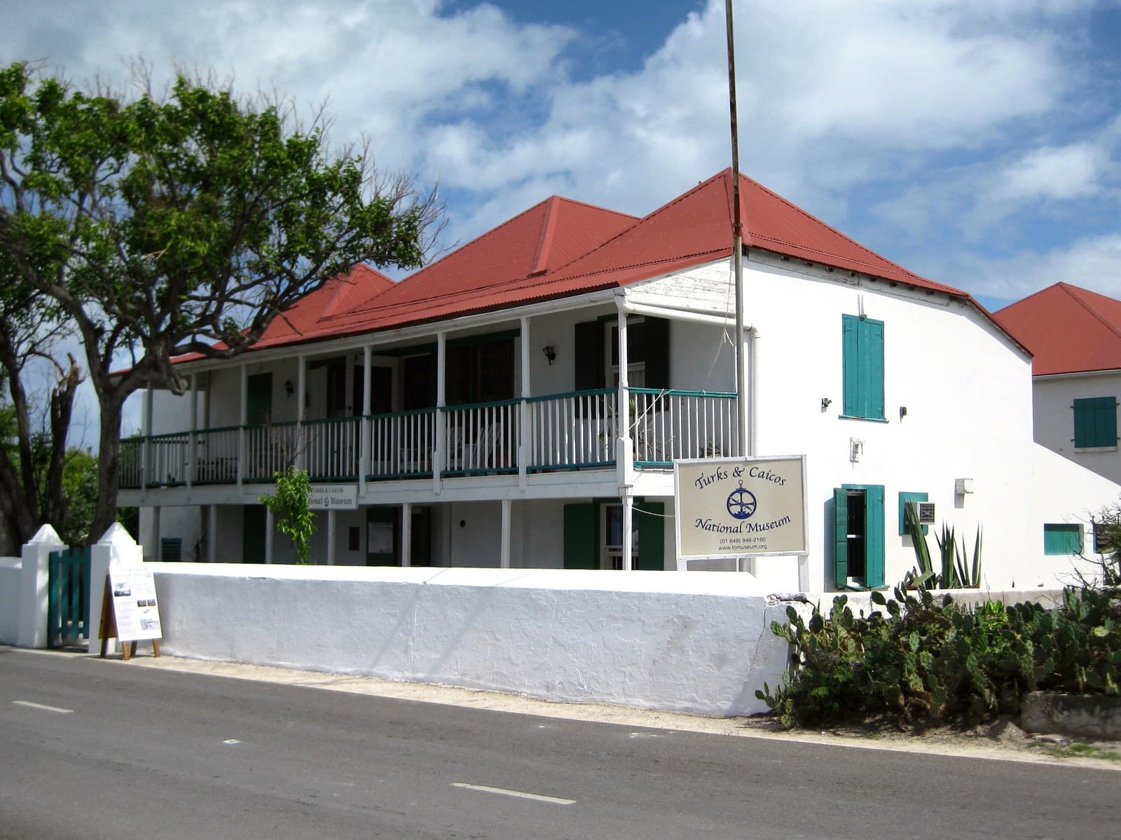
Cockburn Town. The capital, on the western shore of Grand Turk, is a two-street town of limestone and timber houses built by salt proprietors and shipping agents. Front Street and Duke Street face the sea; behind them lie the salinas, so the historic centre of the capital is arranged around an industrial salt works. Guinep House, raised by a shipwright in local limestone with a ship's mast among its supports, has held the Turks and Caicos National Museum since 1991 (Turks and Caicos National Museum).
 Cockburn Town was built on salt raked from ponds behind the shore, an industry worked by enslaved people and then by their descendants until it collapsed in the twentieth century. Photograph by Peacemonger, public domain, via Wikimedia Commons.
Cockburn Harbour and Balfour Town. South Caicos was the third salt town and is the least altered of the three; Deane's Dock, the sluice gates and the Boiling Hole that fed the ponds through a natural channel in the limestone survive because almost nothing was built over them. Salt Cay, whose one settlement is Balfour Town, was once among the richer places in the British Caribbean per head, and the White House built by the Harriott family still stands above the pans that paid for it (Salt Cay).
Kew, Bambarra and Providenciales. Kew on North Caicos sits beside Wade's Green, the best-preserved Loyalist plantation in the region; Bambarra on Middle Caicos carries the name of the Bambara people; and Providenciales, home to Grace Bay and the modern economy, has grown up around the ruined estate at Cheshire Hall.
Lucayan Taino people reached these islands from Hispaniola around the year 700 and lived here for some seven centuries. The clearest evidence is on Middle Caicos, where the settlement archaeologists call MC-6 was occupied into the early sixteenth century. Its plaza holds a stone-lined court whose alignments track the solstices and equinoxes, and a cleared limestone road some six hundred metres long runs from the site to Armstrong Pond, one of the best natural salt ponds in the country, which suggests salt was being harvested here in an organised way centuries before any European arrived (Visit TCI). Within about thirty years of Columbus, Spanish slaving voyages had emptied the islands entirely.
Grand Turk has a long-standing claim to be Guanahani, where Columbus made his first landfall on 12 October 1492. Supporters point to the log's description of a large natural harbour with other islands in view, and to reconstructions that apply the shorter Italian mile Columbus used and correct for magnetic variation, moving the terminus southeast toward the Turks Islands. Most scholars still favour San Salvador, formerly Watling Island, with Samana Cay the strongest rival; the Grand Turk case runs a distant third, and since the original log was lost within a generation and survives only through a partial copy of a copy, the question may never be closed (Britannica). A marker on Grand Turk states the local claim, and the National Museum presents it as an argument.
The islands were resettled for salt. Bermudians were working the ponds on Salt Cay by 1673 and on Grand Turk by 1678, at first seasonally from March to November, and by 1681 the settlement on Grand Turk was permanent. They improved the natural salinas into rock-walled pans with sluice gates and windmill pumps, and brought enslaved Africans to do the raking. The trade was contested throughout: Bermudians, Bahamians and the Spanish all pressed claims, French forces raided more than once, and in 1766 the islands passed under the government of the Bahamas (Turks and Caicos National Museum).
The second wave came after the American Revolution. Around forty Loyalist families, dispossessed in Georgia and East Florida, took land grants on the Caicos Islands from the 1780s and arrived with more than a thousand enslaved people to plant sea island cotton. The crop failed within a generation, ruined by hurricanes, thin soil and the chenille bug, and by about 1820 most planters had gone, abandoning the land and often the people they had brought.
Seven years later the sea delivered the event that shaped the modern population. In March 1841 the Spanish brig Trouvadore, running Africans illegally to the sugar estates of Cuba more than three decades after Britain had banned the trade, struck the reef off East Caicos. Around 280 to 300 people had been loaded aboard in West Africa and about a hundred died on the crossing; 193 survivors reached shore alive with the whole Spanish crew. Because they had landed in a British colony they could not lawfully be enslaved. The crew were arrested and shipped away, twenty-four Africans went on to Nassau, and 168 were bound to salt proprietors on Grand Turk for a year's apprenticeship and then freed. That single group increased the colony's population by about seven per cent, and Bambarra on Middle Caicos, named for the Bambara people of the Niger valley, is traditionally held to be where many settled (Trouvadore). A large part of this country therefore traces its ancestry to a shipwreck rather than to the trade the wreck interrupted. Archaeologists located a wooden wreck off East Caicos in 2004, and a joint expedition with the United States government confirmed the identification in 2008 (Turks and Caicos National Museum).
Slavery ended across the British Caribbean on 1 August 1834. Administratively the islands were passed around for a century and a half: annexed to the Bahamas from 1799, transferred to Jamaica in 1873, made a separate colony in 1962, administered from Nassau again from 1965, and given their own governor in 1973 and a constitution in 1976. The first chief minister under it, James Alexander George Smith McCartney, died in a plane crash in 1980 at thirty-four and remains the territory's only national hero.
Both halves of the country's name are older than the country. The Turks Islands were named for the Turk's cap cactus, Melocactus intortus, whose red flowering crown reminded sailors of a fez. Caicos comes from the Lucayan caya hico, a string of islands, so the map preserves a word of the people the Spanish removed beside a European joke about a plant (Government of the Turks and Caicos Islands).
The language of home and street is Turks and Caicos Creole, an English-lexicon Creole with some 34,000 speakers. Linguists treat it as closely related to Bahamian Creole and highly intelligible with Bermudian speech, which is what its history predicts: Bermudian salt rakers held the islands from the 1670s, enslaved Africans arrived both directly and by way of the Carolinas and Georgia, bringing features shared with Gullah Geechee, and a Jamaican administration from the 1870s to 1962 layered Patois vocabulary on top (Turks and Caicos Islands Creole). It has no official status and no standard orthography, and younger speakers drift toward general Caribbean English.
Ripsaw is the national music and there's nothing quite like it on the neighbouring islands. A carpenter's handsaw is held against the body and scraped with a knife blade, a nail or a screwdriver while the player flexes the blade to bend the pitch, producing a dry rasping pulse that gives the music its name. Around the saw sit a goatskin drum, an accordion, a box guitar and a triangle, and Middle and North Caicos are its home ground. The closest relative is Bahamian rake-and-scrape, and both descend from the same nineteenth-century mixture of European dance forms and African rhythm; ripsaw players will tell you the difference is in the hand (Ripsaw music).
The music belongs to a wider masquerade tradition. Enslaved people here sang and danced in the streets at Christmas in masks and homemade costumes, a practice called massin', and its modern descendant is Maskanoo, held on Boxing Day and named from a collision of masquerade and Junkanoo (Visit TCI). The kitchen keeps its own record of a place with no rivers and almost no soil: conch cracked, stewed or cut raw with lime and pepper, hominy grits with boiled fish, peas and grits, johnnycake and bush teas.
Christianity is close to universal here and denominational identity is public rather than private. Baptists are the largest single body, followed by the Church of God, Anglicans, Methodists, Seventh-day Adventists and, growing quickly with Haitian migration, Roman Catholics. The Anglican presence came with the Bermudians, and St Mary's Pro-Cathedral in Cockburn Town is the oldest religious foundation on Grand Turk; Wesleyan Methodist missionaries arrived in the salt era and were among the few Europeans to record the lives of enslaved rakers at all.
Religion in the salt islands was practical work. Congregations prayed for men crossing the Passage in open lighters, buried the drowned when there was a body, and kept the registers that are now the main written trace of ordinary islanders. The Africans freed from the Trouvadore were baptised, given English names and taught English, which is why those mission registers, for all their coercion, are the documents that let their descendants find them at all.
A death here is a community event before it is a family one. The sequence runs viewing, wake, church service, graveside service and burial, and in the older practice the body stayed at home and was buried within twenty-four hours in a coffin made on the island from whatever timber came to hand. The wake fills the yard with neighbours, hymns, food from other households and talk about the dead that lasts most of the night. What has grown rather than faded is the printed memorial: an order of service carrying the obituary and photographs, often with buttons or shirts worn by the family (Times of the Islands).
Burial is a matter of family ground. Each island has cemeteries, but plots within them are held and tended by families across generations, and older graves sit on family land and along the shore. The Grand Turk Public Cemetery lies between the road and the sea, and the National Museum has run a volunteer project to photograph and index its stones before salt spray takes the lettering, since many markers are soft limestone and already half illegible (Turks and Caicos National Museum).
The salinas hold no marker for the people who spent their working lives in them, and the most famous of those workers left a book instead of a grave. Mary Prince, born enslaved in Bermuda in 1788, was sent to Grand Turk and raked salt there for about ten years from 1802, standing in brine that ate into her legs, and the account she dictated in London in 1831, The History of Mary Prince, a West Indian Slave, Related by Herself, was the first narrative by a Black woman published in Britain (Turks and Caicos National Museum). Emancipation Day on 1 August is the territory's collective act of remembrance, and Mary Prince's testimony is what the salinas are read through.
The Turks and Caicos were administered from the Bahamas and then from Jamaica before becoming a separate territory, so the older records are elsewhere.
Salt built the islands. The Bermudians came to rake it from the seventeenth century, and the loyalist planters arrived after 1783 with enslaved people to work cotton, which failed within a generation and left the population and the salt. The slave registers of the 1820s and 1830s name the enslaved, and the compensation records of 1834 name the owners.
The event that defines the modern population is the wreck of the Trouvadore. In 1841 a Spanish brig running Africans illegally to Cuba, more than three decades after Britain had banned the trade, struck the reef off East Caicos. Around 280 to 300 people had been loaded in West Africa; about a hundred died on the crossing; 193 survivors reached shore alive. Because they landed in a British colony they could not lawfully be enslaved: 24 went on to Nassau and 168 were bound to salt proprietors for a year's apprenticeship and then freed. That single group increased the colony's population by around seven per cent, and Bambarra on Middle Caicos, named for the Bambara people of the Niger valley, is traditionally where many settled. The wreck was located in 2004 and confirmed in 2008.
Anglican and Methodist registers, and civil registration held by the Registrar General in Grand Turk, carry the rest.
The Turks and Caicos National Museum opened in Guinep House on Grand Turk in 1991 and holds the territory's most significant collection. Its centrepiece is the Molasses Reef Wreck, a Spanish or Portuguese caravel of about nineteen metres that struck the edge of the Caicos Bank early in the sixteenth century, probably around 1513. Treasure hunters found it in 1976 and announced it as the Pinta, which the ordnance disproved, then blew craters in the site with pipe bombs to extract material. The government invited the Institute of Nautical Archaeology to excavate properly between 1982 and 1985, more than ten tons of timber, weapons, tools and ceramics were recovered, and the collection came back to the islands in 1990. It is the oldest European shipwreck in the Americas to be scientifically excavated, and nobody can yet say which ship it was (Molasses Reef Wreck).
The Turks and Caicos National Trust, established in 1992, holds the two great Loyalist sites. Cheshire Hall on Providenciales, begun around 1783 by Thomas Stubbs, is the only estate on that island to keep a full set of stone buildings. Wade's Green at Kew, granted to his brother Wade Stubbs for property lost in Florida, is among the best-preserved Loyalist plantations in the Caribbean, with the great house, kitchen, overseer's house, enslaved people's houses and boundary walls still legible on the ground (Turks and Caicos National Trust).
Weather is the standing threat. Hurricane Ike passed over Grand Turk in September 2008 and damaged 80 to 95 per cent of the island's buildings; Irma and Maria came three weeks apart in September 2017. The salt infrastructure has no comparable protection: gates rust, pond walls slump and sheds lose their roofs, and the ruins of the industry that created the country are the least-conserved part of its heritage.
Hurricane Ike had one constructive consequence. The territory has no national archive, and the devastation of Grand Turk in 2008 showed how exposed its paper record was, so the British Library's Endangered Archives Programme funded a pilot titled "From the brink", which in 2010 surveyed government offices, churches, private collections and the National Museum and rescued material from a structurally unsound building (Endangered Archives Programme). A later project, The Archives of Forgotten Places, digitised church records from 1799 to 1922 and government records from 1850 to 1950 and published them free (EAP914).
The National Museum has put a reference site online covering the salt industry, the Loyalist plantations, the slave registers of 1822 to 1834, Mary Prince and the slave ships, which serves as the working history of the islands for schools and family researchers. Times of the Islands and its history supplement Astrolabe have published local scholarship for three decades and keep their back numbers free to read.
The economic centre moved west within one lifetime. Providenciales had a few hundred residents and no paved road in 1970; it now holds most of the population, the airport and the resort strip along Grace Bay, and tourism with offshore finance accounts for the great majority of output. The salt islands, once the whole economy, are the quiet ones.
Governance has been the other defining recent story, and it should be reported plainly. A commission of inquiry under Sir Robin Auld, sitting from 2008, reported in 2009 that there were clear signs of systemic corruption and serious dishonesty in government; Premier Michael Misick resigned in March 2009, and in August 2009 the United Kingdom suspended parts of the constitution, dissolved the House of Assembly and the cabinet, and vested executive and legislative power in the governor (JURIST). Direct rule lasted until elections in November 2012 under a new constitution effective from 15 October 2012, with reforms to public finance and the civil service imposed as conditions. The prosecutions ran on for years: in February 2026 Misick was convicted on three counts of bribery over land deals and sentenced to four years and twenty-six days (The Sun).
Against that background the cultural work has been steady and local. Maskanoo has run for more than fifteen years, ripsaw is taught rather than simply inherited, and a growing number of islanders trace their descent from the Trouvadore Africans with public pride.
An archive brought home. More than ten tons of material from the Molasses Reef Wreck, excavated after treasure hunters had bombed the site, was conserved and returned to the islands in 1990.
A slave ship identified and claimed. The wreck of the Trouvadore, whose survivors were freed under British law in 1841, was located in 2004 and confirmed in 2008, giving a name and a date to an ancestry much of the population already carried.
A saw kept in the band. Ripsaw came through the collapse of the salt economy intact, and Maskanoo each Boxing Day puts it before the largest audience it has had.
Cockburn Town was built on salt raked from ponds behind the shore, an industry worked by enslaved people and then by their descendants until it collapsed in the twentieth century. Photograph by Peacemonger, public domain, via Wikimedia Commons.
Cockburn Harbour and Balfour Town. South Caicos was the third salt town and is the least altered of the three; Deane's Dock, the sluice gates and the Boiling Hole that fed the ponds through a natural channel in the limestone survive because almost nothing was built over them. Salt Cay, whose one settlement is Balfour Town, was once among the richer places in the British Caribbean per head, and the White House built by the Harriott family still stands above the pans that paid for it (Salt Cay).
Kew, Bambarra and Providenciales. Kew on North Caicos sits beside Wade's Green, the best-preserved Loyalist plantation in the region; Bambarra on Middle Caicos carries the name of the Bambara people; and Providenciales, home to Grace Bay and the modern economy, has grown up around the ruined estate at Cheshire Hall.
Lucayan Taino people reached these islands from Hispaniola around the year 700 and lived here for some seven centuries. The clearest evidence is on Middle Caicos, where the settlement archaeologists call MC-6 was occupied into the early sixteenth century. Its plaza holds a stone-lined court whose alignments track the solstices and equinoxes, and a cleared limestone road some six hundred metres long runs from the site to Armstrong Pond, one of the best natural salt ponds in the country, which suggests salt was being harvested here in an organised way centuries before any European arrived (Visit TCI). Within about thirty years of Columbus, Spanish slaving voyages had emptied the islands entirely.
Grand Turk has a long-standing claim to be Guanahani, where Columbus made his first landfall on 12 October 1492. Supporters point to the log's description of a large natural harbour with other islands in view, and to reconstructions that apply the shorter Italian mile Columbus used and correct for magnetic variation, moving the terminus southeast toward the Turks Islands. Most scholars still favour San Salvador, formerly Watling Island, with Samana Cay the strongest rival; the Grand Turk case runs a distant third, and since the original log was lost within a generation and survives only through a partial copy of a copy, the question may never be closed (Britannica). A marker on Grand Turk states the local claim, and the National Museum presents it as an argument.
The islands were resettled for salt. Bermudians were working the ponds on Salt Cay by 1673 and on Grand Turk by 1678, at first seasonally from March to November, and by 1681 the settlement on Grand Turk was permanent. They improved the natural salinas into rock-walled pans with sluice gates and windmill pumps, and brought enslaved Africans to do the raking. The trade was contested throughout: Bermudians, Bahamians and the Spanish all pressed claims, French forces raided more than once, and in 1766 the islands passed under the government of the Bahamas (Turks and Caicos National Museum).
The second wave came after the American Revolution. Around forty Loyalist families, dispossessed in Georgia and East Florida, took land grants on the Caicos Islands from the 1780s and arrived with more than a thousand enslaved people to plant sea island cotton. The crop failed within a generation, ruined by hurricanes, thin soil and the chenille bug, and by about 1820 most planters had gone, abandoning the land and often the people they had brought.
Seven years later the sea delivered the event that shaped the modern population. In March 1841 the Spanish brig Trouvadore, running Africans illegally to the sugar estates of Cuba more than three decades after Britain had banned the trade, struck the reef off East Caicos. Around 280 to 300 people had been loaded aboard in West Africa and about a hundred died on the crossing; 193 survivors reached shore alive with the whole Spanish crew. Because they had landed in a British colony they could not lawfully be enslaved. The crew were arrested and shipped away, twenty-four Africans went on to Nassau, and 168 were bound to salt proprietors on Grand Turk for a year's apprenticeship and then freed. That single group increased the colony's population by about seven per cent, and Bambarra on Middle Caicos, named for the Bambara people of the Niger valley, is traditionally held to be where many settled (Trouvadore). A large part of this country therefore traces its ancestry to a shipwreck rather than to the trade the wreck interrupted. Archaeologists located a wooden wreck off East Caicos in 2004, and a joint expedition with the United States government confirmed the identification in 2008 (Turks and Caicos National Museum).
Slavery ended across the British Caribbean on 1 August 1834. Administratively the islands were passed around for a century and a half: annexed to the Bahamas from 1799, transferred to Jamaica in 1873, made a separate colony in 1962, administered from Nassau again from 1965, and given their own governor in 1973 and a constitution in 1976. The first chief minister under it, James Alexander George Smith McCartney, died in a plane crash in 1980 at thirty-four and remains the territory's only national hero.
Both halves of the country's name are older than the country. The Turks Islands were named for the Turk's cap cactus, Melocactus intortus, whose red flowering crown reminded sailors of a fez. Caicos comes from the Lucayan caya hico, a string of islands, so the map preserves a word of the people the Spanish removed beside a European joke about a plant (Government of the Turks and Caicos Islands).
The language of home and street is Turks and Caicos Creole, an English-lexicon Creole with some 34,000 speakers. Linguists treat it as closely related to Bahamian Creole and highly intelligible with Bermudian speech, which is what its history predicts: Bermudian salt rakers held the islands from the 1670s, enslaved Africans arrived both directly and by way of the Carolinas and Georgia, bringing features shared with Gullah Geechee, and a Jamaican administration from the 1870s to 1962 layered Patois vocabulary on top (Turks and Caicos Islands Creole). It has no official status and no standard orthography, and younger speakers drift toward general Caribbean English.
Ripsaw is the national music and there's nothing quite like it on the neighbouring islands. A carpenter's handsaw is held against the body and scraped with a knife blade, a nail or a screwdriver while the player flexes the blade to bend the pitch, producing a dry rasping pulse that gives the music its name. Around the saw sit a goatskin drum, an accordion, a box guitar and a triangle, and Middle and North Caicos are its home ground. The closest relative is Bahamian rake-and-scrape, and both descend from the same nineteenth-century mixture of European dance forms and African rhythm; ripsaw players will tell you the difference is in the hand (Ripsaw music).
The music belongs to a wider masquerade tradition. Enslaved people here sang and danced in the streets at Christmas in masks and homemade costumes, a practice called massin', and its modern descendant is Maskanoo, held on Boxing Day and named from a collision of masquerade and Junkanoo (Visit TCI). The kitchen keeps its own record of a place with no rivers and almost no soil: conch cracked, stewed or cut raw with lime and pepper, hominy grits with boiled fish, peas and grits, johnnycake and bush teas.
Christianity is close to universal here and denominational identity is public rather than private. Baptists are the largest single body, followed by the Church of God, Anglicans, Methodists, Seventh-day Adventists and, growing quickly with Haitian migration, Roman Catholics. The Anglican presence came with the Bermudians, and St Mary's Pro-Cathedral in Cockburn Town is the oldest religious foundation on Grand Turk; Wesleyan Methodist missionaries arrived in the salt era and were among the few Europeans to record the lives of enslaved rakers at all.
Religion in the salt islands was practical work. Congregations prayed for men crossing the Passage in open lighters, buried the drowned when there was a body, and kept the registers that are now the main written trace of ordinary islanders. The Africans freed from the Trouvadore were baptised, given English names and taught English, which is why those mission registers, for all their coercion, are the documents that let their descendants find them at all.
A death here is a community event before it is a family one. The sequence runs viewing, wake, church service, graveside service and burial, and in the older practice the body stayed at home and was buried within twenty-four hours in a coffin made on the island from whatever timber came to hand. The wake fills the yard with neighbours, hymns, food from other households and talk about the dead that lasts most of the night. What has grown rather than faded is the printed memorial: an order of service carrying the obituary and photographs, often with buttons or shirts worn by the family (Times of the Islands).
Burial is a matter of family ground. Each island has cemeteries, but plots within them are held and tended by families across generations, and older graves sit on family land and along the shore. The Grand Turk Public Cemetery lies between the road and the sea, and the National Museum has run a volunteer project to photograph and index its stones before salt spray takes the lettering, since many markers are soft limestone and already half illegible (Turks and Caicos National Museum).
The salinas hold no marker for the people who spent their working lives in them, and the most famous of those workers left a book instead of a grave. Mary Prince, born enslaved in Bermuda in 1788, was sent to Grand Turk and raked salt there for about ten years from 1802, standing in brine that ate into her legs, and the account she dictated in London in 1831, The History of Mary Prince, a West Indian Slave, Related by Herself, was the first narrative by a Black woman published in Britain (Turks and Caicos National Museum). Emancipation Day on 1 August is the territory's collective act of remembrance, and Mary Prince's testimony is what the salinas are read through.
The Turks and Caicos were administered from the Bahamas and then from Jamaica before becoming a separate territory, so the older records are elsewhere.
Salt built the islands. The Bermudians came to rake it from the seventeenth century, and the loyalist planters arrived after 1783 with enslaved people to work cotton, which failed within a generation and left the population and the salt. The slave registers of the 1820s and 1830s name the enslaved, and the compensation records of 1834 name the owners.
The event that defines the modern population is the wreck of the Trouvadore. In 1841 a Spanish brig running Africans illegally to Cuba, more than three decades after Britain had banned the trade, struck the reef off East Caicos. Around 280 to 300 people had been loaded in West Africa; about a hundred died on the crossing; 193 survivors reached shore alive. Because they landed in a British colony they could not lawfully be enslaved: 24 went on to Nassau and 168 were bound to salt proprietors for a year's apprenticeship and then freed. That single group increased the colony's population by around seven per cent, and Bambarra on Middle Caicos, named for the Bambara people of the Niger valley, is traditionally where many settled. The wreck was located in 2004 and confirmed in 2008.
Anglican and Methodist registers, and civil registration held by the Registrar General in Grand Turk, carry the rest.
The Turks and Caicos National Museum opened in Guinep House on Grand Turk in 1991 and holds the territory's most significant collection. Its centrepiece is the Molasses Reef Wreck, a Spanish or Portuguese caravel of about nineteen metres that struck the edge of the Caicos Bank early in the sixteenth century, probably around 1513. Treasure hunters found it in 1976 and announced it as the Pinta, which the ordnance disproved, then blew craters in the site with pipe bombs to extract material. The government invited the Institute of Nautical Archaeology to excavate properly between 1982 and 1985, more than ten tons of timber, weapons, tools and ceramics were recovered, and the collection came back to the islands in 1990. It is the oldest European shipwreck in the Americas to be scientifically excavated, and nobody can yet say which ship it was (Molasses Reef Wreck).
The Turks and Caicos National Trust, established in 1992, holds the two great Loyalist sites. Cheshire Hall on Providenciales, begun around 1783 by Thomas Stubbs, is the only estate on that island to keep a full set of stone buildings. Wade's Green at Kew, granted to his brother Wade Stubbs for property lost in Florida, is among the best-preserved Loyalist plantations in the Caribbean, with the great house, kitchen, overseer's house, enslaved people's houses and boundary walls still legible on the ground (Turks and Caicos National Trust).
Weather is the standing threat. Hurricane Ike passed over Grand Turk in September 2008 and damaged 80 to 95 per cent of the island's buildings; Irma and Maria came three weeks apart in September 2017. The salt infrastructure has no comparable protection: gates rust, pond walls slump and sheds lose their roofs, and the ruins of the industry that created the country are the least-conserved part of its heritage.
Hurricane Ike had one constructive consequence. The territory has no national archive, and the devastation of Grand Turk in 2008 showed how exposed its paper record was, so the British Library's Endangered Archives Programme funded a pilot titled "From the brink", which in 2010 surveyed government offices, churches, private collections and the National Museum and rescued material from a structurally unsound building (Endangered Archives Programme). A later project, The Archives of Forgotten Places, digitised church records from 1799 to 1922 and government records from 1850 to 1950 and published them free (EAP914).
The National Museum has put a reference site online covering the salt industry, the Loyalist plantations, the slave registers of 1822 to 1834, Mary Prince and the slave ships, which serves as the working history of the islands for schools and family researchers. Times of the Islands and its history supplement Astrolabe have published local scholarship for three decades and keep their back numbers free to read.
The economic centre moved west within one lifetime. Providenciales had a few hundred residents and no paved road in 1970; it now holds most of the population, the airport and the resort strip along Grace Bay, and tourism with offshore finance accounts for the great majority of output. The salt islands, once the whole economy, are the quiet ones.
Governance has been the other defining recent story, and it should be reported plainly. A commission of inquiry under Sir Robin Auld, sitting from 2008, reported in 2009 that there were clear signs of systemic corruption and serious dishonesty in government; Premier Michael Misick resigned in March 2009, and in August 2009 the United Kingdom suspended parts of the constitution, dissolved the House of Assembly and the cabinet, and vested executive and legislative power in the governor (JURIST). Direct rule lasted until elections in November 2012 under a new constitution effective from 15 October 2012, with reforms to public finance and the civil service imposed as conditions. The prosecutions ran on for years: in February 2026 Misick was convicted on three counts of bribery over land deals and sentenced to four years and twenty-six days (The Sun).
Against that background the cultural work has been steady and local. Maskanoo has run for more than fifteen years, ripsaw is taught rather than simply inherited, and a growing number of islanders trace their descent from the Trouvadore Africans with public pride.
An archive brought home. More than ten tons of material from the Molasses Reef Wreck, excavated after treasure hunters had bombed the site, was conserved and returned to the islands in 1990.
A slave ship identified and claimed. The wreck of the Trouvadore, whose survivors were freed under British law in 1841, was located in 2004 and confirmed in 2008, giving a name and a date to an ancestry much of the population already carried.
A saw kept in the band. Ripsaw came through the collapse of the salt economy intact, and Maskanoo each Boxing Day puts it before the largest audience it has had.
National Overview
Notable Cities
Historical Foundations
Linguistic and Etymological Roots
Cultural Identity
Religion and Spirituality
Remembrance and Mourning Traditions
Tracing a Family in Turks and Caicos Islands
Heritage Preservation Efforts
Digital Heritage
Contemporary Cultural Influences
Success Stories
References and resources
- Turks and Caicos National Museum: Guinep House and its collections.
- Molasses Reef Wreck, Wikipedia: the caravel and its excavation.
- Trouvadore, Wikipedia: the 1841 wreck and its survivors.
- Turks and Caicos National Museum, Mary Prince: the salt ponds and her narrative.
- Visit TCI, History of the Salt Industry: ponds, windmills, decline.
- Endangered Archives Programme, EAP408: records digitised after Ike.
- Turks and Caicos National Trust: Cheshire Hall.
- JURIST, Constitution Suspended: the Auld inquiry and its aftermath.
- Britannica, Turks and Caicos Islands: geography and government.