Heritage · Country
Sint Maarten Culture and Heritage
On 29 May 1848 the twenty-six people held at Diamond Estate walked north across a line drawn in 1648 and were free, because France freed its colonies fifteen years before the Netherlands did. This is a guide to Sint Maarten's heritage, from the Great Salt Pond to the ponum dance.Written to last.
By Confinity Heritage Editorial · Updated 2026-08-17 · 8-minute readQuiet tools, kept out of the way.
On the morning of 29 May 1848, twenty-six people, the entire enslaved population of the Diamond Estate plantation, walked off the property and kept going north. They crossed a line drawn across the island two centuries earlier and reached the French plantation at Mount Fortune, where they were recorded as free men and women. The Dutch commander, Johannes Willem van Romondt, wrote to his French counterpart asking for them back and was told that anyone reaching French ground was free. His letters survive, and UNESCO inscribed them on the Memory of the World register in 2017 as Route to Freedom.
That is the Dutch side of Sint Maarten in one document: a small territory whose most consequential fact is the border along its northern edge, and whose archive records what that border cost the planters and what it gave the people they held. Sint Maarten occupies the southern third of an island of about 87 square kilometres, has been a constituent country of the Kingdom of the Netherlands since 2010, speaks English while writing Dutch on its statutes, and has built almost its whole modern economy on a harbour and a runway.
Sint Maarten covers about 34 square kilometres, the southern portion of an island shared with the French collectivity of Saint Martin, and counted roughly 58,500 residents in 2023 (Britannica). The land is low and dry, a run of volcanic hills falling to bays and to two large bodies of shallow water: the Great Salt Pond behind Philipsburg, and the Simpson Bay Lagoon, which the border cuts in half. Since 10 October 2010, when the Netherlands Antilles was dissolved, Sint Maarten has been a country within the Kingdom of the Netherlands, running its own parliament, government and courts while defence, foreign affairs and nationality remain Kingdom matters. Dutch and English are both official, English is what people speak, and it is the language of instruction in most schools. Tourism accounts for around four fifths of employment, the population draws on more than a hundred nationalities, and most residents are Christian across Methodist, Anglican, Roman Catholic, Adventist and Pentecostal congregations.
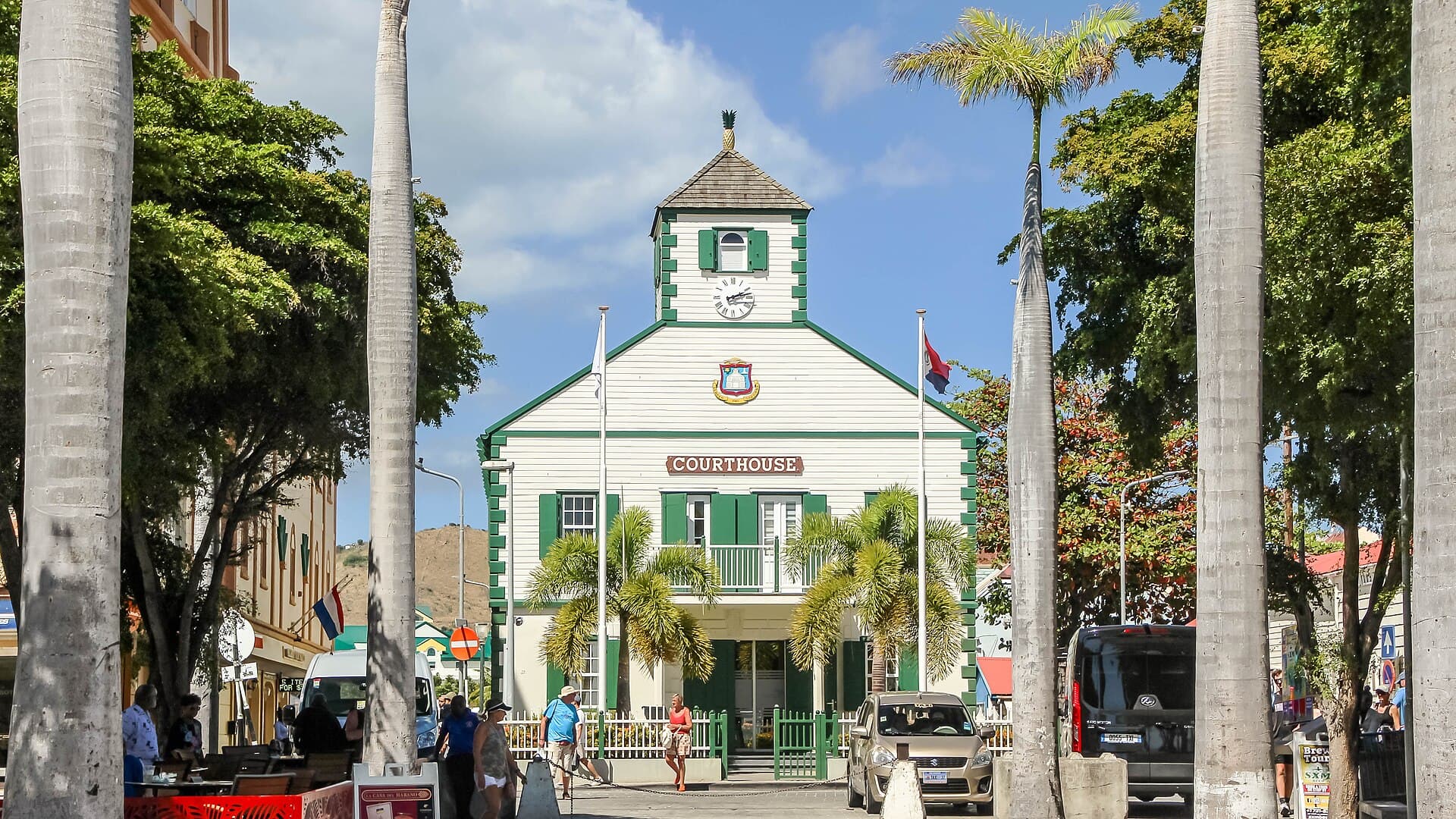
Philipsburg. The capital sits on a sandbar a few hundred metres wide, with Great Bay on one side and the Great Salt Pond on the other, which is the whole explanation of the town: it was laid out where the salt was, and the streets follow the bar. John Philips, a Scot in Dutch service, founded it in 1733 to concentrate the island's trade in one place, and Front Street and Back Street still run its length (Wikipedia). Wathey Square, where the pier meets Front Street, holds the courthouse of 1793, commissioned by Commander Willem Hendrik Rink and used in turn as jail, weighing house, post office, council room and court, with a pineapple carved on its cupola as the old sign of welcome. The Methodist church, the Roman Catholic church and the Heritage Foundation's museum sit within a few minutes' walk of it, and the cruise pier brings in more than two million passengers a year.
 The island has been split between Dutch and French administrations since 1648, which makes it one of the oldest continuously observed land borders anywhere, and there is no checkpoint on it. Photograph by georama, CC BY 3.0, via Wikimedia Commons.
Simpson Bay and the lagoon. West of the capital, Princess Juliana International Airport occupies the strip between the sea and the largest inland lagoon in the Lesser Antilles, a body of water the border cuts in two. Simpson Bay was a fishing village before the runway arrived.
The villages. Cole Bay, Cay Hill, Sint Peters, Dutch Quarter, Middle Region and Cul-de-Sac hold most of the resident population, and the graveyard at Cul-de-Sac marks one of the first Dutch settlements on the island.
The island was settled from South America several thousand years ago, and the Arawakan-speaking people who arrived in the centuries before contact called it Soualiga, land of salt, for the ponds that dry out behind its bays. Kalinago groups displaced or absorbed them before Europeans came. Christopher Columbus sighted it on 11 November 1493, the feast of Martin of Tours, named it Isla de San Martín and sailed on without landing, which is why a Caribbean island carries the name of a fourth-century bishop of Gaul.
The Dutch came for the salt. Ships out of Zeeland were loading from the ponds by the 1620s, and in 1631 the Dutch West India Company built Fort Amsterdam above Little Bay, the first Dutch fort in the Caribbean. Spain took it in 1633 and held it fifteen years. In 1644 Peter Stuyvesant, then governor of Curaçao, led an expedition to retake the fort, was hit by a cannonball while climbing the rampart, and lost the leg he afterwards replaced with a wooden one; he failed, and went on to govern New Amsterdam (Wikipedia). Spain abandoned the island in 1648, and the Dutch and French settlers who came back found themselves sharing it.
The Treaty of Concordia was signed on 23 March 1648 on the hill since called Mount Concordia, by Martin Thomas for the States General and Robert de Longvilliers for France. It gave the Dutch the southern third with the Great Salt Pond in it, guaranteed free movement between the two parts, and provided for shared use of the roadsteads and the salt. The story everyone tells is different. In the legend each side picked a walker; the two set off back to back along the shore, the Frenchman fortified with wine and the Dutchman with gin; the gin worked faster, the Dutchman lay down to sleep it off, and France ended up with the larger share. Sint Maarteners tell it against themselves, and it remains a story: the documented reason for the division is that a French squadron was in the offing while terms were agreed (Wikipedia). The line then moved sixteen times before the settlement of 1817 fixed it near where it now runs.
Salt gave way to sugar and cotton, and to the enslavement of Africans on estates whose names survive as districts: Diamond, Belvedere, Mary's Fancy, Industry. Emancipation came late here. The Netherlands abolished slavery in its colonies on 1 July 1863, fifteen years after France, and in that gap the border became a route out. After the crossing from Diamond Estate in May 1848 more people went north, planters petitioned for abolition, received no answer, and began paying wages rather than risk losing everyone (UNESCO Memory of the World).
The salt trade faded early in the twentieth century and the island got poorer. Duty-free port status in 1939, a wartime airstrip that became Princess Juliana International Airport, and resort tourism from the 1950s turned the economy around within a generation. Sint Maarten was an island territory of the Netherlands Antilles from 1954, voted for separate country status in 2000, and attained it on 10 October 2010.
Dutch and English are both official here, and the everyday balance between them is unlike anywhere else in the Kingdom. English is the language of the street, the radio, the churches, the courts in practice and, since well before 2010, of most classrooms; a study of schooling here and on Saba traced how English displaced Dutch as the medium of instruction over the second half of the twentieth century (Caribbean Journal of Education). The reason is migration: labour came from Anguilla, St Kitts, Nevis, Saba and further down the Anglophone chain while the Dutch presence stayed thin, and the language of the workforce became the language of the island. Dutch survives in statute, in a handful of schools and in the qualifications a student needs to study in the Netherlands, which is the tension the education debates return to.
The place names record the same layering. Soualiga is still in use, on the pier at Philipsburg and in the names of newspapers and radio stations, and Sint Maarten and Saint Martin are one saint in two spellings. Philipsburg is named for its Scottish founder in Dutch employ, Wathey Square for a twentieth-century political family, and Cul-de-Sac and Colombier sit on the Dutch map in French.
The ponum is the island's own dance, the only folk dance to survive here, and it belongs to emancipation. Accounts hold that the freed people danced it under a flamboyant tree afterwards known as the July Tree when the proclamation was read; it is danced to the Brim song, taught in schools and performed every 1 July (Sint Maarten National Heritage Foundation). Around it sit string band music, quadrille figures inherited from the estate era, and modern calypso and soca.
Carnival is where the Dutch side's calendar shows itself. It began in 1969 and settled into late April, timed to end on 30 April, then the birthday of Queen Juliana and a Kingdom holiday; the season runs for a fortnight in the Carnival Village beside the salt pond, with calypso and soca competitions, a Jouvert street party before dawn in which paint, powder and trucks of music move through the capital, and the Grand Parade at the end. The French side holds its Carnival in February on the Catholic calendar and finishes on Ash Wednesday. Two carnivals thirty minutes apart by road is the clearest illustration of what the partition actually does.
The kitchen keeps johnny cakes, saltfish, conch and dumplings, callaloo soup and goat water, and the island's own drink is guavaberry, a rum liqueur made from a small dark hill fruit that ripens before Christmas and is carried house to house through the season. There is also one anthem for the whole island. Gerard Kemps, a Dutch Catholic priest posted to the French side in 1954, wrote "O Sweet Saint Martin's Land" in English in 1958 and then a French version with different words and a different tune; both halves adopted it, which makes it a rare national song sung on either side of an international frontier (Wikipedia).
Christianity here is denominationally mixed in a way that reflects where the workforce came from. Methodism arrived with British Caribbean influence in the nineteenth century and remains one of the strongest traditions on the Dutch side, its Philipsburg chapel and cemetery among the oldest working institutions in the town, and the Anglican, Catholic, Adventist, Baptist and Pentecostal churches all have long-established congregations alongside newer ones founded by arrivals from Haiti, Jamaica, the Dominican Republic and Guyana. The saint the island is named for is Martin of Tours, the Roman soldier who cut his cloak in half for a beggar at Amiens, and his feast on 11 November is the one day the whole island keeps together.
Beneath the churches runs the vocabulary of obeah and jumbie common across the Anglophone eastern Caribbean: protective practices, readings, and a body of belief about the recently dead which most families will acknowledge and few discuss with outsiders. Small Hindu and Muslim communities have places of worship here, and Rastafari has a visible presence.
A death on Sint Maarten is announced on the radio. Death notices and funeral times are read out on the local stations, which is how the island finds out, and how people who left for the Netherlands or the United States hear as well. The house then fills. Family and neighbours sit up with the bereaved through the nights before the burial, with hymn singing, scripture, coffee and food, and in some families the gathering extends across nine nights in the pattern kept through the Anglophone Caribbean. The funeral is a church service, most often Methodist, Anglican or Catholic, the congregation sings the coffin out and walks behind it, and the repast afterwards runs as long as anyone wants to stay.
Burial is a family matter and a territorial one. Tombs are built above ground in concrete, painted and repainted, and family plots are added to across generations. The graveyard at Cul-de-Sac, on the site of one of the earliest Dutch settlements, holds the foundations of a Protestant church, the remains of a dwelling and an oven, and the graves of families who were here before Philipsburg existed (Sint Maarten monuments). The Methodist cemetery in Philipsburg carries much of the town's nineteenth and twentieth-century population. Both are visited, cleaned and flowered.
Public remembrance runs on two dates. Emancipation Day, 1 July, marks the abolition of 1863 with a ceremony, the ponum danced in the open, and the Diamond 26 Run for Freedom, in which people retrace the route the twenty-six took north in 1848. On 11 November, Sint Maarten Day, delegations from both governments meet at the obelisk on the road between Philipsburg and Marigot, put up in 1948 for the three-hundredth anniversary of the partition, and mark a shared feast day for a divided island (Concordia Monument).
Sint Maarten shares an island with a French collectivity, and the family records are split by a line drawn in 1648.
The Dutch side's registers are held in Philipsburg and in the Netherlands, and the French side's in Marigot and in France, but families have always crossed. There is no border control on the island, so a household may have births registered on both sides across generations.
The Dutch slave registers, kept for the colony in the decades before abolition, and the emancipation records are the primary source for Afro-Caribbean families. The dates matter enormously here: France abolished slavery in its colonies in 1848, the Netherlands not until 1863. On 29 May 1848 the twenty-six people held at Diamond Estate on the Dutch side walked north across the boundary and were free, and the Dutch authorities, unable to hold the line, effectively conceded fifteen years before the law changed. That date is the island's emancipation day.
Church registers, Methodist and Catholic above all, carry baptisms and marriages.
The modern record is complicated by scale and by weather. The population multiplied several times over in the tourism decades, drawing people from Haiti, the Dominican Republic, Jamaica, India and elsewhere, and Hurricane Irma in 2017 destroyed a very large share of the island's buildings, government offices among them. Digitising what survived has been an explicit priority since.
The Sint Maarten National Heritage Foundation is the island's principal custodian. Its museum opened in 1989 on Front Street, and the foundation was formed on 4 October 1993 by a merger of the Sint Maarten Museum Foundation with the National Park Foundation, which is why one body handles both the archaeology and the protected areas (Sint Maarten National Heritage Foundation). Its collections cover Amerindian material, the salt industry, the plantation era, the 1801 wreck of HMS Proselyte off Fort Amsterdam, and twentieth-century island life.
Fort Amsterdam is the oldest structure on the Dutch side and the most exposed. It sits on private hotel land above Little Bay, it has weathered badly, and its future has been argued over for years. The Emilio Wilson Estate is the counter-example. Trace Wilson was born into slavery on that plantation in 1818; her descendant Emilio Wilson bought the land and kept it out of development, and after his death the government committed in September 2013 to buying some 37 hectares for a protected heritage park (Dutch Caribbean Nature Alliance). The plantation house opened as a museum in 2017.
Development pressure is the honest counterweight. A recent study of heritage and the luxury property market here argued that historic sites are routinely traded and cleared rather than protected, and estate ruins associated with people who escaped slavery have been lost to construction (Social Sciences). The island has a monuments ordinance and a list of designated buildings, and enforcement on 34 square kilometres of this land value is a continuing argument.
The Route to Freedom inscription is the centrepiece. The material is a run of correspondence between 1848 and 1863: letters from Van Romondt to the French commander and to the governor of Curaçao, and the replies, documenting how the different abolition dates on one island turned a colonial boundary into a route out of bondage. UNESCO added it to the Memory of the World International Register in 2017, and it is held by the Government of Sint Maarten's Records and Information Management department rather than in a European archive, which matters (UNESCO Memory of the World).
Around it, the Dutch Nationaal Archief has published finding aids and indexes covering slavery in the Netherlands Antilles, including the 1863 emancipation records that name the people freed and the surnames they were given (Nationaal Archief). The Heritage Foundation publishes the national symbols, the anthem and the ponum online, and the island's newspapers of record keep searchable archives.
Two things dominate public life on the Dutch side. The first is the scale of the visitor economy relative to the country: more than two million cruise passengers come through Great Bay each year, Princess Juliana is the air hub for Anguilla, Saba, Sint Eustatius and St Barths, and around four fifths of the workforce depends on that traffic, which concentrates risk in a way a hurricane season makes obvious.
The second is governance. Reports through the 2000s and 2010s described corruption and patronage across public institutions, and the Kingdom's response has been supervisory. The Netherlands and Sint Maarten agreed a protocol in 2015 to establish an Integrity Chamber; when it stalled, the Kingdom Council of Ministers issued a formal instruction in April 2017 requiring it, and the chamber now investigates conduct in government and its entities with members appointed by both governments and the Kingdom (Integrity Chamber). Hurricane Irma, which crossed on 6 September 2017 as a Category 5 storm and damaged most buildings on both sides, sharpened the argument: Dutch reconstruction money of about 470 million euros was routed through a World Bank trust fund whose steering committee gives the Netherlands, Sint Maarten and the Bank a seat each, an arrangement the Dutch government defends as prudence and many on the island read as distrust (World Bank). The rebuilt airport terminal reopened in 2024.
Alongside that, Sint Maarten artists work in soca, calypso and reggae across the eastern Caribbean, and the diaspora in the Netherlands and the United States keeps ties through Carnival and Emancipation Day.
A border archive recognised. The letters documenting how enslaved people used the 1648 line to reach freedom between 1848 and 1863 were inscribed by UNESCO in 2017 and are held on the island by Sint Maarten's own records office.
A plantation kept out of the market. The Emilio Wilson Estate, where Trace Wilson was born enslaved in 1818, was bought for the public in 2013 and its great house opened as a museum in 2017.
A dance that survived the plantation. The ponum, danced when the emancipation proclamation was read, is the official national dance, taught in schools and performed every 1 July.
One anthem for two jurisdictions. "O Sweet Saint Martin's Land", written in 1958 by a priest working on the French side, is sung on both halves in two languages and two tunes.
The island has been split between Dutch and French administrations since 1648, which makes it one of the oldest continuously observed land borders anywhere, and there is no checkpoint on it. Photograph by georama, CC BY 3.0, via Wikimedia Commons.
Simpson Bay and the lagoon. West of the capital, Princess Juliana International Airport occupies the strip between the sea and the largest inland lagoon in the Lesser Antilles, a body of water the border cuts in two. Simpson Bay was a fishing village before the runway arrived.
The villages. Cole Bay, Cay Hill, Sint Peters, Dutch Quarter, Middle Region and Cul-de-Sac hold most of the resident population, and the graveyard at Cul-de-Sac marks one of the first Dutch settlements on the island.
The island was settled from South America several thousand years ago, and the Arawakan-speaking people who arrived in the centuries before contact called it Soualiga, land of salt, for the ponds that dry out behind its bays. Kalinago groups displaced or absorbed them before Europeans came. Christopher Columbus sighted it on 11 November 1493, the feast of Martin of Tours, named it Isla de San Martín and sailed on without landing, which is why a Caribbean island carries the name of a fourth-century bishop of Gaul.
The Dutch came for the salt. Ships out of Zeeland were loading from the ponds by the 1620s, and in 1631 the Dutch West India Company built Fort Amsterdam above Little Bay, the first Dutch fort in the Caribbean. Spain took it in 1633 and held it fifteen years. In 1644 Peter Stuyvesant, then governor of Curaçao, led an expedition to retake the fort, was hit by a cannonball while climbing the rampart, and lost the leg he afterwards replaced with a wooden one; he failed, and went on to govern New Amsterdam (Wikipedia). Spain abandoned the island in 1648, and the Dutch and French settlers who came back found themselves sharing it.
The Treaty of Concordia was signed on 23 March 1648 on the hill since called Mount Concordia, by Martin Thomas for the States General and Robert de Longvilliers for France. It gave the Dutch the southern third with the Great Salt Pond in it, guaranteed free movement between the two parts, and provided for shared use of the roadsteads and the salt. The story everyone tells is different. In the legend each side picked a walker; the two set off back to back along the shore, the Frenchman fortified with wine and the Dutchman with gin; the gin worked faster, the Dutchman lay down to sleep it off, and France ended up with the larger share. Sint Maarteners tell it against themselves, and it remains a story: the documented reason for the division is that a French squadron was in the offing while terms were agreed (Wikipedia). The line then moved sixteen times before the settlement of 1817 fixed it near where it now runs.
Salt gave way to sugar and cotton, and to the enslavement of Africans on estates whose names survive as districts: Diamond, Belvedere, Mary's Fancy, Industry. Emancipation came late here. The Netherlands abolished slavery in its colonies on 1 July 1863, fifteen years after France, and in that gap the border became a route out. After the crossing from Diamond Estate in May 1848 more people went north, planters petitioned for abolition, received no answer, and began paying wages rather than risk losing everyone (UNESCO Memory of the World).
The salt trade faded early in the twentieth century and the island got poorer. Duty-free port status in 1939, a wartime airstrip that became Princess Juliana International Airport, and resort tourism from the 1950s turned the economy around within a generation. Sint Maarten was an island territory of the Netherlands Antilles from 1954, voted for separate country status in 2000, and attained it on 10 October 2010.
Dutch and English are both official here, and the everyday balance between them is unlike anywhere else in the Kingdom. English is the language of the street, the radio, the churches, the courts in practice and, since well before 2010, of most classrooms; a study of schooling here and on Saba traced how English displaced Dutch as the medium of instruction over the second half of the twentieth century (Caribbean Journal of Education). The reason is migration: labour came from Anguilla, St Kitts, Nevis, Saba and further down the Anglophone chain while the Dutch presence stayed thin, and the language of the workforce became the language of the island. Dutch survives in statute, in a handful of schools and in the qualifications a student needs to study in the Netherlands, which is the tension the education debates return to.
The place names record the same layering. Soualiga is still in use, on the pier at Philipsburg and in the names of newspapers and radio stations, and Sint Maarten and Saint Martin are one saint in two spellings. Philipsburg is named for its Scottish founder in Dutch employ, Wathey Square for a twentieth-century political family, and Cul-de-Sac and Colombier sit on the Dutch map in French.
The ponum is the island's own dance, the only folk dance to survive here, and it belongs to emancipation. Accounts hold that the freed people danced it under a flamboyant tree afterwards known as the July Tree when the proclamation was read; it is danced to the Brim song, taught in schools and performed every 1 July (Sint Maarten National Heritage Foundation). Around it sit string band music, quadrille figures inherited from the estate era, and modern calypso and soca.
Carnival is where the Dutch side's calendar shows itself. It began in 1969 and settled into late April, timed to end on 30 April, then the birthday of Queen Juliana and a Kingdom holiday; the season runs for a fortnight in the Carnival Village beside the salt pond, with calypso and soca competitions, a Jouvert street party before dawn in which paint, powder and trucks of music move through the capital, and the Grand Parade at the end. The French side holds its Carnival in February on the Catholic calendar and finishes on Ash Wednesday. Two carnivals thirty minutes apart by road is the clearest illustration of what the partition actually does.
The kitchen keeps johnny cakes, saltfish, conch and dumplings, callaloo soup and goat water, and the island's own drink is guavaberry, a rum liqueur made from a small dark hill fruit that ripens before Christmas and is carried house to house through the season. There is also one anthem for the whole island. Gerard Kemps, a Dutch Catholic priest posted to the French side in 1954, wrote "O Sweet Saint Martin's Land" in English in 1958 and then a French version with different words and a different tune; both halves adopted it, which makes it a rare national song sung on either side of an international frontier (Wikipedia).
Christianity here is denominationally mixed in a way that reflects where the workforce came from. Methodism arrived with British Caribbean influence in the nineteenth century and remains one of the strongest traditions on the Dutch side, its Philipsburg chapel and cemetery among the oldest working institutions in the town, and the Anglican, Catholic, Adventist, Baptist and Pentecostal churches all have long-established congregations alongside newer ones founded by arrivals from Haiti, Jamaica, the Dominican Republic and Guyana. The saint the island is named for is Martin of Tours, the Roman soldier who cut his cloak in half for a beggar at Amiens, and his feast on 11 November is the one day the whole island keeps together.
Beneath the churches runs the vocabulary of obeah and jumbie common across the Anglophone eastern Caribbean: protective practices, readings, and a body of belief about the recently dead which most families will acknowledge and few discuss with outsiders. Small Hindu and Muslim communities have places of worship here, and Rastafari has a visible presence.
A death on Sint Maarten is announced on the radio. Death notices and funeral times are read out on the local stations, which is how the island finds out, and how people who left for the Netherlands or the United States hear as well. The house then fills. Family and neighbours sit up with the bereaved through the nights before the burial, with hymn singing, scripture, coffee and food, and in some families the gathering extends across nine nights in the pattern kept through the Anglophone Caribbean. The funeral is a church service, most often Methodist, Anglican or Catholic, the congregation sings the coffin out and walks behind it, and the repast afterwards runs as long as anyone wants to stay.
Burial is a family matter and a territorial one. Tombs are built above ground in concrete, painted and repainted, and family plots are added to across generations. The graveyard at Cul-de-Sac, on the site of one of the earliest Dutch settlements, holds the foundations of a Protestant church, the remains of a dwelling and an oven, and the graves of families who were here before Philipsburg existed (Sint Maarten monuments). The Methodist cemetery in Philipsburg carries much of the town's nineteenth and twentieth-century population. Both are visited, cleaned and flowered.
Public remembrance runs on two dates. Emancipation Day, 1 July, marks the abolition of 1863 with a ceremony, the ponum danced in the open, and the Diamond 26 Run for Freedom, in which people retrace the route the twenty-six took north in 1848. On 11 November, Sint Maarten Day, delegations from both governments meet at the obelisk on the road between Philipsburg and Marigot, put up in 1948 for the three-hundredth anniversary of the partition, and mark a shared feast day for a divided island (Concordia Monument).
Sint Maarten shares an island with a French collectivity, and the family records are split by a line drawn in 1648.
The Dutch side's registers are held in Philipsburg and in the Netherlands, and the French side's in Marigot and in France, but families have always crossed. There is no border control on the island, so a household may have births registered on both sides across generations.
The Dutch slave registers, kept for the colony in the decades before abolition, and the emancipation records are the primary source for Afro-Caribbean families. The dates matter enormously here: France abolished slavery in its colonies in 1848, the Netherlands not until 1863. On 29 May 1848 the twenty-six people held at Diamond Estate on the Dutch side walked north across the boundary and were free, and the Dutch authorities, unable to hold the line, effectively conceded fifteen years before the law changed. That date is the island's emancipation day.
Church registers, Methodist and Catholic above all, carry baptisms and marriages.
The modern record is complicated by scale and by weather. The population multiplied several times over in the tourism decades, drawing people from Haiti, the Dominican Republic, Jamaica, India and elsewhere, and Hurricane Irma in 2017 destroyed a very large share of the island's buildings, government offices among them. Digitising what survived has been an explicit priority since.
The Sint Maarten National Heritage Foundation is the island's principal custodian. Its museum opened in 1989 on Front Street, and the foundation was formed on 4 October 1993 by a merger of the Sint Maarten Museum Foundation with the National Park Foundation, which is why one body handles both the archaeology and the protected areas (Sint Maarten National Heritage Foundation). Its collections cover Amerindian material, the salt industry, the plantation era, the 1801 wreck of HMS Proselyte off Fort Amsterdam, and twentieth-century island life.
Fort Amsterdam is the oldest structure on the Dutch side and the most exposed. It sits on private hotel land above Little Bay, it has weathered badly, and its future has been argued over for years. The Emilio Wilson Estate is the counter-example. Trace Wilson was born into slavery on that plantation in 1818; her descendant Emilio Wilson bought the land and kept it out of development, and after his death the government committed in September 2013 to buying some 37 hectares for a protected heritage park (Dutch Caribbean Nature Alliance). The plantation house opened as a museum in 2017.
Development pressure is the honest counterweight. A recent study of heritage and the luxury property market here argued that historic sites are routinely traded and cleared rather than protected, and estate ruins associated with people who escaped slavery have been lost to construction (Social Sciences). The island has a monuments ordinance and a list of designated buildings, and enforcement on 34 square kilometres of this land value is a continuing argument.
The Route to Freedom inscription is the centrepiece. The material is a run of correspondence between 1848 and 1863: letters from Van Romondt to the French commander and to the governor of Curaçao, and the replies, documenting how the different abolition dates on one island turned a colonial boundary into a route out of bondage. UNESCO added it to the Memory of the World International Register in 2017, and it is held by the Government of Sint Maarten's Records and Information Management department rather than in a European archive, which matters (UNESCO Memory of the World).
Around it, the Dutch Nationaal Archief has published finding aids and indexes covering slavery in the Netherlands Antilles, including the 1863 emancipation records that name the people freed and the surnames they were given (Nationaal Archief). The Heritage Foundation publishes the national symbols, the anthem and the ponum online, and the island's newspapers of record keep searchable archives.
Two things dominate public life on the Dutch side. The first is the scale of the visitor economy relative to the country: more than two million cruise passengers come through Great Bay each year, Princess Juliana is the air hub for Anguilla, Saba, Sint Eustatius and St Barths, and around four fifths of the workforce depends on that traffic, which concentrates risk in a way a hurricane season makes obvious.
The second is governance. Reports through the 2000s and 2010s described corruption and patronage across public institutions, and the Kingdom's response has been supervisory. The Netherlands and Sint Maarten agreed a protocol in 2015 to establish an Integrity Chamber; when it stalled, the Kingdom Council of Ministers issued a formal instruction in April 2017 requiring it, and the chamber now investigates conduct in government and its entities with members appointed by both governments and the Kingdom (Integrity Chamber). Hurricane Irma, which crossed on 6 September 2017 as a Category 5 storm and damaged most buildings on both sides, sharpened the argument: Dutch reconstruction money of about 470 million euros was routed through a World Bank trust fund whose steering committee gives the Netherlands, Sint Maarten and the Bank a seat each, an arrangement the Dutch government defends as prudence and many on the island read as distrust (World Bank). The rebuilt airport terminal reopened in 2024.
Alongside that, Sint Maarten artists work in soca, calypso and reggae across the eastern Caribbean, and the diaspora in the Netherlands and the United States keeps ties through Carnival and Emancipation Day.
A border archive recognised. The letters documenting how enslaved people used the 1648 line to reach freedom between 1848 and 1863 were inscribed by UNESCO in 2017 and are held on the island by Sint Maarten's own records office.
A plantation kept out of the market. The Emilio Wilson Estate, where Trace Wilson was born enslaved in 1818, was bought for the public in 2013 and its great house opened as a museum in 2017.
A dance that survived the plantation. The ponum, danced when the emancipation proclamation was read, is the official national dance, taught in schools and performed every 1 July.
One anthem for two jurisdictions. "O Sweet Saint Martin's Land", written in 1958 by a priest working on the French side, is sung on both halves in two languages and two tunes.
National Overview
Notable Cities
Historical Foundations
Linguistic and Etymological Roots
Cultural Identity
Religion and Spirituality
Remembrance and Mourning Traditions
Tracing a Family in Sint Maarten
Heritage Preservation Efforts
Digital Heritage
Contemporary Cultural Influences
Success Stories
References and resources
- UNESCO Memory of the World, Route to Freedom: the 1848 to 1863 correspondence inscribed in 2017.
- Treaty of Concordia, Wikipedia: the 1648 partition, its signatories and the walking-race legend.
- Fort Amsterdam (Sint Maarten), Wikipedia: the 1631 fort, the Spanish occupation and Stuyvesant's failed assault of 1644.
- Sint Maarten National Heritage Foundation and Museum: the museum of 1989 and the foundation of 1993.
- Sint Maarten National Symbols: the ponum dance, the anthem and the flag.
- Dutch Caribbean Nature Alliance, Emilio Wilson Estate: Trace Wilson, Emilio Wilson and the 2013 purchase.
- Caribbean Journal of Education, Schooling in Sint Maarten and Saba: English replacing Dutch as the language of instruction.
- O Sweet Saint Martin's Land, Wikipedia: Gerard Kemps and the shared anthem.
- Integrity Chamber, Sint Maarten: the body established after the 2015 protocol and the 2017 Kingdom instruction.
- World Bank, Sint Maarten Recovery Trust Fund: the post-Irma reconstruction fund and its governance.
- Nationaal Archief, Slavernijverleden: Dutch research guides to slavery records for the Antilles.
- Encyclopaedia Britannica, Sint Maarten: geography, government and economy.