Heritage · Country
Caribbean Netherlands Culture and Heritage
Bonaire, Sint Eustatius and Saba became special municipalities of the Netherlands itself on 10 October 2010, though they lie 800 kilometres apart and share little beyond that arrangement. This is a guide to their heritage, from the salt-pan slave huts to the First Salute of 1776 and Saba's drawn-thread lace.Written to last.
By Confinity Heritage Editorial · Updated 2026-08-17 · 8-minute readQuiet tools, kept out of the way.
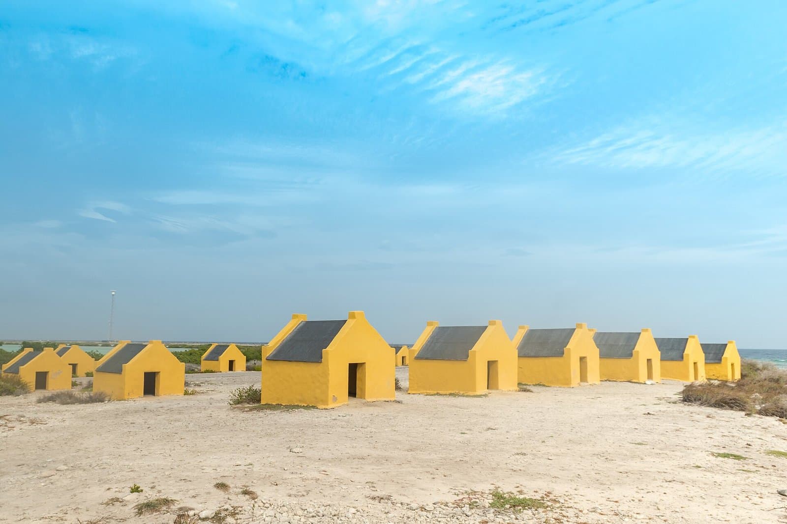
On the south coast of Bonaire, strung along the white coral gravel between the salt pans and the sea, stand about thirty stone huts roughly the size of a garden shed. An adult cannot stand up inside one. They were built in 1850 for the enslaved men and women who cut salt in the pans, who came down from Rincon at the north end of the island and slept here through the working week, and they are still there, repainted, a few metres from the water. Dutch colonial slavery ended thirteen years later.
Bonaire is one of three islands that on 10 October 2010 became something no other Caribbean territory is: not a country in free association, not a colony, not an overseas department, but a special municipality of the Netherlands. The other two, Sint Eustatius and Saba, lie roughly 800 kilometres away in the Leeward Islands, speak English at home, and have little in common with Bonaire beyond that. This profile treats all three separately, because the status is recent and the inheritances under it are not shared.
The Caribbean Netherlands is an administrative category rather than a place. When the Netherlands Antilles was dissolved in 2010, Curaçao and Sint Maarten became constituent countries of the Kingdom alongside Aruba, while Bonaire, Sint Eustatius and Saba each became an openbaar lichaam, a public body inside the Netherlands itself, answerable to The Hague and outside any Dutch province (Wikipedia). Residents vote in Dutch and European elections, the US dollar replaced the guilder in 2011, and Dutch ministries run health, education and policing.
Geographically the three have nothing to do with each other. Bonaire covers 288 square kilometres about 80 kilometres off the Venezuelan coast, dry and low, with roughly 26,000 residents. Sint Eustatius is 21 square kilometres of the Leeward Islands, built around the dormant cone of the Quill, with about 3,300 people. Saba is smaller again at 13 square kilometres, one steep volcano rising to Mount Scenery at around 870 metres, the highest ground in the Kingdom of the Netherlands, with some 2,150 residents and no beach to speak of. Dutch is official on all three; Papiamentu is the recognised language of Bonaire and English of Saba and Statia.
Kralendijk. Bonaire's capital is a low waterfront town facing the uninhabited islet of Klein Bonaire, with Fort Oranje at one end and the Terramar Museum along the front.
Rincon. Inland to the north, in a valley chosen because it couldn't be seen from the sea, Rincon is the oldest settlement on Bonaire and the place the island treats as its cultural source. The Mangazina di Rei, the king's storehouse where enslaved workers collected rations, is now a museum, and Dia di Rincon on 30 April is the largest gathering of the Bonairean year.
Oranjestad, Sint Eustatius. The Statian capital is two towns joined by a cliff path. Upper Town holds Fort Oranje, the Simon Doncker house and the roofless walls of the Honen Dalim synagogue. Lower Town, at the foot of the cliff, was the commercial engine of the eighteenth-century Atlantic, and its warehouse walls now run into the surf and past it.
The Bottom and Windwardside. Saba's four villages sit on ledges of a volcano. The Bottom, the capital, occupies a shallow bowl about 250 metres up; Windwardside, higher again, holds the Harry L. Johnson Museum and the Saba Lace Room; St Johns and Zion's Hill, long known as Hell's Gate, complete the set. Every house is white with a red roof and green shutters.
Bonaire. Caquetío people, Arawakan speakers from the Venezuelan mainland, settled the island long before contact and left rock paintings in the caves at Boca Onima and Spelonk. Spain claimed it in 1499 and within a generation decided it had no use for the people: from about 1515 the Caquetío were deported wholesale to Hispaniola to work the mines of Santo Domingo, leaving the island a stock ranch (Wikipedia). The Dutch took it in 1636 and made it a salt works, because the rainfall would support nothing else.
Salt is therefore Bonaire's colonial history. Enslaved Africans and their descendants cut and raked it in shallow pans on the southern flats named by colour, Rode Pan, Witte Pan, Oranje Pan and Blauwe Pan, barefoot in brine under an unbroken sun. Until 1850 they slept in the open or in shelters they built themselves; that year the administration put up the rows of stone huts that survive at Rode Pan and Witte Pan, two people to a hut, and marked each pan with an obelisk in the matching colour so ships knew where to load. Slavery was abolished on 1 July 1863, freeing 758 people here, most of whom had belonged to the government itself (JusticeInfo). The pans are worked industrially today, and the huts are kept, painted and marked as monuments.
Sint Eustatius. Statia was a barren rock with a good roadstead. In 1756 the Dutch declared it a free port open to all flags and cargoes without duty, hundreds of warehouses went up along a mile of shore below the cliff, and the island became a clearing house through which European manufactures, North American provisions, sugar and, in very large numbers, enslaved Africans were bought and re-sold to whoever would pay. Contemporaries called it the Golden Rock, and the slave trade was a substantial part of that traffic, conducted on the same quays as everything else.
On 16 November 1776 the American brig Andrew Doria, flying the Continental colours and carrying a copy of the Declaration of Independence, entered the roadstead and fired a thirteen-gun salute. Governor Johannes de Graaff ordered Fort Oranje to answer with eleven guns, the reply due to a sovereign flag, and so gave the United States its first acknowledgement by a foreign official (Wikipedia). Britain didn't forget it. Admiral George Rodney seized the island on 3 February 1781, auctioned its warehouses down to the timbers, and had the Jewish merchant community rounded up and stripped of property, deporting thirty men to St Kitts (Wikipedia). The island that had handled the commerce of an ocean never recovered the trade.
Saba. The Dutch settled Saba in the 1640s from Sint Eustatius, and English-speaking families from Ireland, Scotland and the English islands arrived quickly enough that it has been Anglophone ever since, whoever governed it. There was no harbour and no road; everything landed at Ladder Bay and went up the cliff on the Ladder, roughly 800 steps cut into the rock by hand. Engineers told the island in the twentieth century that a road couldn't be built on that gradient. Josephus Lambert Hassell, a Saban who studied civil engineering by correspondence course, began one anyway in 1938; Fort Bay to The Bottom was finished by 1943, Windwardside reached by 1951, and the airstrip at Flat Point by 1963, all of it laid by hand (Wikipedia).
Bonaire speaks Papiamentu, the Iberian-based creole of the ABC islands, in a variety that speakers on Curaçao identify immediately. It's the first language of most Bonaireans, used in primary schooling, the island council and church, and it carries proverbs, harvest songs and prayers transmitted orally for generations. Dutch remains the language of law and secondary education, which puts many children in the position of being taught in a language they don't use at home.
Saba and Statia speak English, and have since the seventeenth century. The Saban variety preserves features traceable to the Irish, Scottish and West Country settlers who arrived early and stayed, while Statian English is closer to that of the surrounding Leeward Islands.
The place names record the layers. Bonaire is generally derived from a Caquetío word taken down by early Spanish navigators, and the pretty explanation from French bon air is an invention. Statia's Quill comes from the Dutch kuil, a pit, for the crater, and Hell's Gate was renamed Zion's Hill by residents who tired of the joke.
Bonaire's year turns on the harvest. Simadan marks the end of the sorghum harvest, gathered between February and May, and is celebrated most fully at Rincon on Easter Monday with the wapa, a shuffling processional dance, and instruments that include the bari drum, the scraped wiri and the karko conch shell. The songs are in Papiamentu and anonymous. Late June brings the fire nights of San Juan on the 24th and San Pedro on the 28th, when bonfires are built from harvest waste, people jump the flames, and singers move from house to house opening each visit with the same song. The associated dera gai, the burying of a rooster, is best known today from Aruba, but the fire nights are inventoried on Bonaire as living heritage (Intangible Cultural Heritage Bonaire).
Statia's identity is organised around the day the guns answered. Statia Day on 16 November is the island's holiday, with a ceremony at Fort Oranje and a week of events, and the 1776 salute is the fact every schoolchild here knows. Emancipation on 1 July is marked too, and the island's music, food and Carnival belong to the Anglophone eastern Caribbean.
Saba's distinctive inheritance is made with a needle. In the 1870s a Saban girl, Mary Gertrude Hassell Johnson, was sent to a convent school in Caracas and came back having learned drawn-thread work, in which threads are withdrawn from woven cloth and the rest knotted into open patterns. Sabans call it Spanish work. When regular mail reached the island in 1884 the women of a place whose men were at sea turned it into a mail-order business, writing to American firms whose addresses they took off parcels, and by 1900 lace was among the island's leading exports and stayed a principal source of household income into the 1950s (Wikipedia). A few women still make and sell it.
Bonaire is overwhelmingly Roman Catholic, the result of nineteenth-century mission work among the enslaved and freed population. Saints' days structure the calendar, processions carry hymns in Papiamentu, and the folk vocabulary of brua, charms and cures, sits underneath the parish.
Statia and Saba are Protestant islands with Catholic minorities, which follows from where their settlers came from. Statia has Methodist, Anglican and Adventist congregations beside its Catholic parish, and the Dutch Reformed church of 1755 keeps its tower over Upper Town. It also holds one of the oldest synagogue buildings in the Americas: Honen Dalim, "charitable to the poor", raised in 1739 by a Sephardic merchant community that at its height may have been a quarter of the white population, roofless since it fell derelict after Rodney's sack, its yellow-brick walls stabilised in 2001 (Atlas Obscura). Its cemetery, in use from 1739 to 1824, holds a few dozen stones. Saba, for its size, is well supplied with churches.
Death on all three begins with the house rather than the church. On Bonaire the body is watched overnight, the rosary is said aloud in the front room for eight consecutive evenings before an altar of photographs, candles and flowers, and on the last night the chairs are turned and the windows opened. Graves are above ground, tiled or rendered and repainted by relatives, and 2 November brings families to the cemeteries with brushes and candles.
 These huts were built in 1850 for enslaved people cutting salt. A grown adult cannot stand up inside one, and several people slept in each. They were still in use when slavery ended thirteen years later. Photograph by David Burley, CC BY-SA 1.0, via Wikimedia Commons.
On Statia and Saba the pattern is the Anglophone Caribbean one. Neighbours fill the house between the death and the burial, and in many families the gathering continues across nine nights of singing, prayer, food and storytelling, the ninth being the largest and the one at which the spirit is understood to take its leave (Wikipedia).
Saba does something almost nowhere else in the region does. Sabans have long buried their dead in the garden beside the house rather than a churchyard, in stone-lined cist graves under a slab, so that the villages are threaded with family plots a few steps from the kitchen door. Archaeologists have identified the form as unique within the Dutch Caribbean and as a continuity with rural burial practice brought from the British Isles in the seventeenth century, and it is still in use (Antiquity).
Bonaire, Sint Eustatius and Saba are three very different islands administered together, and their records are Dutch and mostly in the Netherlands.
Sint Eustatius has the largest archive relative to its size, because in the eighteenth century it was the busiest trading port in the Caribbean, the Golden Rock, where hundreds of ships a year called and where the American revolutionaries bought their gunpowder. It was the first foreign territory to salute the American flag, in November 1776, and the British sacked it for that in 1781. The commercial and admiralty records of the period, in The Hague and London, document a population of merchants, sailors and enslaved people out of all proportion to the island's size.
Bonaire's record is salt. The Dutch West India Company worked the pans with enslaved labour, and the slave huts at Rincon still stand; the slave registers of 1839 to 1863, digitised with Curaçao's and Suriname's, name individuals, and the emancipation registers of 1863 record the surnames taken.
Saba, steep and hard to land on, kept a small population of Dutch, Scottish and Irish descent alongside an African-descended one, and its records are correspondingly small and complete.
All three became special municipalities of the Netherlands in 2010, so residents are Dutch and their modern civil registration is Dutch.
Each island keeps a museum, and each museum is a house. The Terramar Museum opened in Kralendijk in August 2016 and runs from the Caquetío period through the deportation, salt and slavery to the twentieth century (InfoBonaire), while the Mangazina di Rei at Rincon tells the same story from the building where rations were issued. The St Eustatius Historical Foundation Museum occupies the Simon Doncker house of about 1740, Rodney's headquarters in 1781, and the Harry L. Johnson Museum in Windwardside is a sea captain's cottage furnished as it was, with the Saba Lace Room nearby.
Statia's archaeology is the richest of the three and the most endangered. Close to three hundred sites have been recorded on 21 square kilometres, from Saladoid villages to plantations to the deposits of Lower Town, and the St Eustatius Center for Archaeological Research, founded in 2000, has run field schools there for a quarter of a century (Openbaar Lichaam Sint Eustatius). The problem is the sea: those warehouses were built at the waterline, the shore has retreated, and hurricanes and swell are taking the walls apart faster than anyone can record them.
The 2010 change cuts both ways. Dutch monument law doesn't simply extend to the islands, which keep their own ordinances and their own small budgets, so protection depends on island capacity that is thin by definition on populations of two and three thousand. Against that, the Rijksdienst voor het Cultureel Erfgoed, the Dutch national heritage agency, now works directly in the Caribbean Netherlands and has systematically photographed sites including the salt pans and their huts.
The most useful digital work for families has been the opening of the slavery records, done island by island. The Curaçao registers of 1839 to 1863 don't cover the other islands, which kept their own, so the Nationaal Archief has published separate indexes; the Sint Eustatius material, the borderellen of the general accounting office with the emancipation register of 1862 to 1863, went online as a searchable index in its own right (Nationaal Archief). For a population of a few thousand, that comes close to a complete family tree of the enslaved community at emancipation.
The same archive has assembled a selected digital collection of Statian material from the colonial series in The Hague (Nationaal Archief), and SECAR publishes its excavation reports openly. Bonaire has taken a different route, building an inventory of intangible heritage in Papiamentu and English that documents Simadan, San Juan and San Pedro, the wapa and the instruments, kept by the practitioners themselves. Saba's lace patterns, shipping records and family histories circulate through island historical writing and the Digital Library of the Caribbean.
The most consequential recent event on the three was constitutional. In February 2018 the Dutch government, acting on a committee report describing lawlessness, financial mismanagement, intimidation and neglect of duty in the Statian administration, dissolved the island council, discharged the acting governor and installed a commissioner under a special Restoration Act (NL Times). It was the first intervention of its kind. Democratic institutions came back in stages: an island council election in 2020, a party dialogue from 2023, a new governor in April 2024, and the lapsing of the Restoration Act on 1 September 2024 (NIMD). Statians disagree sharply about whether that was rescue or occupation.
The referendums around the 2010 settlement were mixed. Bonaire voted in September 2004 for direct ties with the Netherlands on 59 per cent and Saba did the same in November 2004 on 86 per cent, but Statia voted in April 2005 to stay inside the Netherlands Antilles by 77 per cent, the only island to do so, and ended up in the new arrangement anyway once the Antilles collapsed (Wikipedia). Statia then voted in December 2014 for more autonomy on a turnout below the binding threshold, and Bonaire voted in December 2015 by 65.55 per cent against its current status, a result The Hague didn't treat as decisive (Wikipedia).
The daily arguments are about money. Imported food and fuel have made the islands expensive, benefits and wages were set below Dutch levels, and young people leave to study and often stay away. Bonaire absorbs cruise arrivals against a fixed water supply, Saba's medical school is much of its economy, and Statia lives with a fuel terminal on its coast and the eighteenth century under its beach.
The huts were kept. The shelters at Rode Pan and Witte Pan, put up in 1850 and abandoned in 1863, were preserved and marked rather than cleared, and are the most direct physical evidence of Dutch Caribbean slavery anywhere.
A road nobody would build. Josephus Lambert Hassell taught himself engineering by post and led Sabans in laying fourteen kilometres of road across a volcano by hand between 1938 and 1963, ending the island's reliance on the Ladder.
Statia's emancipation register is searchable. The island's borderellen and its 1862 to 1863 emancipation register were indexed and put online, giving families a route from a modern surname to a named ancestor.
A craft that paid the bills survived. Saba lace, learned in a Caracas convent in the 1870s and sold by post from 1884, sustained households for seventy years and is still made on the island.
These huts were built in 1850 for enslaved people cutting salt. A grown adult cannot stand up inside one, and several people slept in each. They were still in use when slavery ended thirteen years later. Photograph by David Burley, CC BY-SA 1.0, via Wikimedia Commons.
On Statia and Saba the pattern is the Anglophone Caribbean one. Neighbours fill the house between the death and the burial, and in many families the gathering continues across nine nights of singing, prayer, food and storytelling, the ninth being the largest and the one at which the spirit is understood to take its leave (Wikipedia).
Saba does something almost nowhere else in the region does. Sabans have long buried their dead in the garden beside the house rather than a churchyard, in stone-lined cist graves under a slab, so that the villages are threaded with family plots a few steps from the kitchen door. Archaeologists have identified the form as unique within the Dutch Caribbean and as a continuity with rural burial practice brought from the British Isles in the seventeenth century, and it is still in use (Antiquity).
Bonaire, Sint Eustatius and Saba are three very different islands administered together, and their records are Dutch and mostly in the Netherlands.
Sint Eustatius has the largest archive relative to its size, because in the eighteenth century it was the busiest trading port in the Caribbean, the Golden Rock, where hundreds of ships a year called and where the American revolutionaries bought their gunpowder. It was the first foreign territory to salute the American flag, in November 1776, and the British sacked it for that in 1781. The commercial and admiralty records of the period, in The Hague and London, document a population of merchants, sailors and enslaved people out of all proportion to the island's size.
Bonaire's record is salt. The Dutch West India Company worked the pans with enslaved labour, and the slave huts at Rincon still stand; the slave registers of 1839 to 1863, digitised with Curaçao's and Suriname's, name individuals, and the emancipation registers of 1863 record the surnames taken.
Saba, steep and hard to land on, kept a small population of Dutch, Scottish and Irish descent alongside an African-descended one, and its records are correspondingly small and complete.
All three became special municipalities of the Netherlands in 2010, so residents are Dutch and their modern civil registration is Dutch.
Each island keeps a museum, and each museum is a house. The Terramar Museum opened in Kralendijk in August 2016 and runs from the Caquetío period through the deportation, salt and slavery to the twentieth century (InfoBonaire), while the Mangazina di Rei at Rincon tells the same story from the building where rations were issued. The St Eustatius Historical Foundation Museum occupies the Simon Doncker house of about 1740, Rodney's headquarters in 1781, and the Harry L. Johnson Museum in Windwardside is a sea captain's cottage furnished as it was, with the Saba Lace Room nearby.
Statia's archaeology is the richest of the three and the most endangered. Close to three hundred sites have been recorded on 21 square kilometres, from Saladoid villages to plantations to the deposits of Lower Town, and the St Eustatius Center for Archaeological Research, founded in 2000, has run field schools there for a quarter of a century (Openbaar Lichaam Sint Eustatius). The problem is the sea: those warehouses were built at the waterline, the shore has retreated, and hurricanes and swell are taking the walls apart faster than anyone can record them.
The 2010 change cuts both ways. Dutch monument law doesn't simply extend to the islands, which keep their own ordinances and their own small budgets, so protection depends on island capacity that is thin by definition on populations of two and three thousand. Against that, the Rijksdienst voor het Cultureel Erfgoed, the Dutch national heritage agency, now works directly in the Caribbean Netherlands and has systematically photographed sites including the salt pans and their huts.
The most useful digital work for families has been the opening of the slavery records, done island by island. The Curaçao registers of 1839 to 1863 don't cover the other islands, which kept their own, so the Nationaal Archief has published separate indexes; the Sint Eustatius material, the borderellen of the general accounting office with the emancipation register of 1862 to 1863, went online as a searchable index in its own right (Nationaal Archief). For a population of a few thousand, that comes close to a complete family tree of the enslaved community at emancipation.
The same archive has assembled a selected digital collection of Statian material from the colonial series in The Hague (Nationaal Archief), and SECAR publishes its excavation reports openly. Bonaire has taken a different route, building an inventory of intangible heritage in Papiamentu and English that documents Simadan, San Juan and San Pedro, the wapa and the instruments, kept by the practitioners themselves. Saba's lace patterns, shipping records and family histories circulate through island historical writing and the Digital Library of the Caribbean.
The most consequential recent event on the three was constitutional. In February 2018 the Dutch government, acting on a committee report describing lawlessness, financial mismanagement, intimidation and neglect of duty in the Statian administration, dissolved the island council, discharged the acting governor and installed a commissioner under a special Restoration Act (NL Times). It was the first intervention of its kind. Democratic institutions came back in stages: an island council election in 2020, a party dialogue from 2023, a new governor in April 2024, and the lapsing of the Restoration Act on 1 September 2024 (NIMD). Statians disagree sharply about whether that was rescue or occupation.
The referendums around the 2010 settlement were mixed. Bonaire voted in September 2004 for direct ties with the Netherlands on 59 per cent and Saba did the same in November 2004 on 86 per cent, but Statia voted in April 2005 to stay inside the Netherlands Antilles by 77 per cent, the only island to do so, and ended up in the new arrangement anyway once the Antilles collapsed (Wikipedia). Statia then voted in December 2014 for more autonomy on a turnout below the binding threshold, and Bonaire voted in December 2015 by 65.55 per cent against its current status, a result The Hague didn't treat as decisive (Wikipedia).
The daily arguments are about money. Imported food and fuel have made the islands expensive, benefits and wages were set below Dutch levels, and young people leave to study and often stay away. Bonaire absorbs cruise arrivals against a fixed water supply, Saba's medical school is much of its economy, and Statia lives with a fuel terminal on its coast and the eighteenth century under its beach.
The huts were kept. The shelters at Rode Pan and Witte Pan, put up in 1850 and abandoned in 1863, were preserved and marked rather than cleared, and are the most direct physical evidence of Dutch Caribbean slavery anywhere.
A road nobody would build. Josephus Lambert Hassell taught himself engineering by post and led Sabans in laying fourteen kilometres of road across a volcano by hand between 1938 and 1963, ending the island's reliance on the Ladder.
Statia's emancipation register is searchable. The island's borderellen and its 1862 to 1863 emancipation register were indexed and put online, giving families a route from a modern surname to a named ancestor.
A craft that paid the bills survived. Saba lace, learned in a Caracas convent in the 1870s and sold by post from 1884, sustained households for seventy years and is still made on the island.
National Overview
Notable Cities
Historical Foundations
Linguistic and Etymological Roots
Cultural Identity
Religion and Spirituality
Remembrance and Mourning Traditions
Tracing a Family in Caribbean Netherlands
Heritage Preservation Efforts
Digital Heritage
Contemporary Cultural Influences
Success Stories
References and resources
- Caribbean Netherlands, Wikipedia: the 2010 settlement and the figures.
- Bonaire, Wikipedia: the Caquetío and the deportation of 1515.
- JusticeInfo, Bonaire: a history of slavery, a present of social inequalities: the salt pans, the 1863 emancipation figures and the plaques.
- Sint Eustatius, Wikipedia: the free port and the Golden Rock.
- The First Salute, Wikipedia: the Andrew Doria and 16 November 1776.
- Openbaar Lichaam Sint Eustatius, Archaeology: the recorded sites and SECAR.
- The Road (Saba), Wikipedia: Hassell and the road.
- Saba lace, Wikipedia: Spanish work and the mail-order trade.
- Cist graves on Saba, Antiquity: the island's burial form.
- Nationaal Archief, slavery indexes for Aruba and Sint Eustatius: the Statian records.
- NL Times, Netherlands to take over St Eustatius: the February 2018 intervention.