Heritage · Landmark
Göreme and Cappadocia: cities carved into the living rock
In central Turkey, ancient volcanoes laid down a stone soft enough to carve with hand tools, and for thousands of years people cut homes, churches, dovecotes, and entire underground cities into it. Göreme's painted Byzantine chapels and the deep refuges of Derinkuyu survive in a landscape that the same slow erosion which created it is now wearing away.Written to last.
By Confinity Heritage Editorial · 2026-08-23 · 7-minute readQuiet tools, kept out of the way.
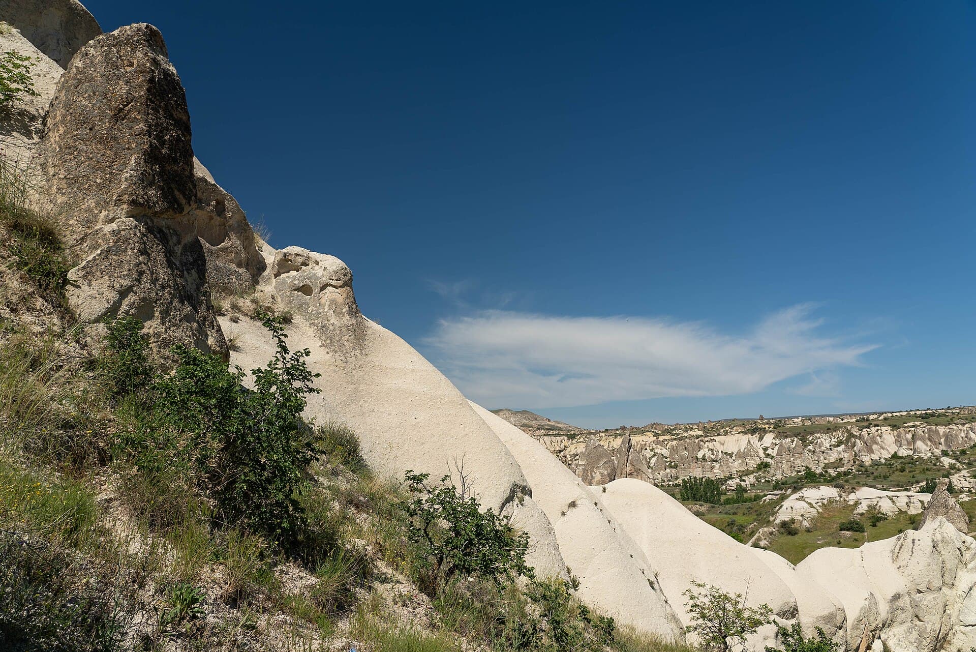
On the high plateau of central Turkey, between the volcanic peaks of Erciyes and Hasan Dağı, the land breaks into valleys of pale stone shaped like nothing else on earth. Cones and pinnacles rise in ranks, some capped with dark boulders balanced like hats, and nearly every one of them has a door. The region is Cappadocia, and its most famous valley carries the name Göreme, a place where the boundary between landscape and architecture dissolved long ago. Since 1985 the valley and its surroundings have been protected as Göreme National Park and the Rock Sites of Cappadocia, one of the first properties UNESCO inscribed under both natural and cultural criteria, because here the geology and the human story cannot be separated.
What makes Cappadocia singular is a simple property of its stone. The rock is soft enough to cut with a pick and a chisel, yet firm enough to hold a room, a stair, a vaulted ceiling. For at least two and a half thousand years, and probably longer, the people of this plateau responded to that invitation. They carved houses, stables, wine presses, granaries, pigeon towers, chapels, monasteries, and, when danger came, whole cities sunk many storeys beneath their fields. The result is a settled landscape turned inside out: instead of raising walls upon the ground, Cappadocians hollowed their lives into it.
The story begins with volcanoes. Between roughly ten million and two million years ago, eruptions of Erciyes, Hasan Dağı, and the smaller Göllüdağ buried the region under deep layers of ash and ignimbrite, which compacted into the rock geologists call tuff. Later flows capped parts of that soft blanket with harder basalt and andesite. Then water, wind, and frost went to work. Where the hard cap protected the tuff beneath, erosion left tall cones and pillars standing while the surrounding rock washed away, producing the pinnacles known locally as peribacaları and in every guidebook as fairy chimneys. Some stand alone like sentries; others cluster into ridges and towers forty metres high. The same softness that let erosion sculpt the valleys is what let people carve them, and that double character, a gift and a vulnerability in one material, runs through everything that follows.
Cutting a room into tuff is faster and cheaper than building one, and the result is cool in the Anatolian summer and warm in the snowbound winter. Writing in the fourth century BC, Xenophon described Anatolian villagers living in dwellings dug into the earth, with their animals and provisions beside them, a passage often read as the earliest written notice of this way of life. Over the centuries the carving grew ambitious. Villages such as Uçhisar and Ortahisar grew around castle-like rock towers riddled with chambers. Farmers cut storerooms whose stable temperatures kept grain, fruit, and wine through the year, and the tradition survives today in the region's carved depots, where citrus and potatoes are still stored at scale.
The most charming expression of the carved economy is the dovecote. Across the valleys, thousands of small pigeon houses were cut high into cliff faces, many in the eighteenth and nineteenth centuries, their entrances painted white and patterned to catch the birds' attention. The pigeons were not kept for meat but for their droppings, gathered once a year and spread on the vineyards and orchards that fed the region. It was a complete system: the rock housed the people, the people housed the birds, and the birds fed the soil that fed the people.
The plateau sat on contested ground for much of its history, crossed by armies and raiders moving between Anatolia and the east. Against that danger Cappadocians built downward. More than two hundred underground complexes are known in the region, and the greatest of them are true cities. Derinkuyu descends roughly eighty-five metres through many levels, with stables and presses near the surface, living quarters, kitchens, and chapels below, and storerooms and wells deeper still. Ventilation shafts kept air moving through the whole depth, and the passages could be sealed from inside by rolling stone doors, thick discs weighing hundreds of kilograms that ran in carved channels and could not be forced from without. Estimates of its capacity run into the many thousands. Nearby Kaymaklı spreads wider and shallower, a warren of low tunnels and communal rooms of which four levels are open to visitors today.
The oldest cuttings may go back to the Phrygians in the early first millennium BC, though the question is still argued. What is certain is that the cities reached their fullest use in the Byzantine centuries, when Cappadocia became a frontier province facing the Arab caliphates. During the raids that swept the plateau from the seventh century onward, villagers drove their animals below, rolled the doors shut, and waited in the dark until the danger passed. The refuges kept their value long after that frontier closed, serving again during later invasions, and Derinkuyu's tunnels were only fully brought back to light in 1963, when a resident knocked through a cellar wall and found a passage that did not end.
Cappadocia was also holy ground. Basil of Caesarea, the fourth-century bishop whose rule still shapes Orthodox monasticism, came from this province, and from at least the fourth century hermits and monastic communities settled the Göreme valley, cutting cells, refectories, and churches into the cones. The valley now protected as the Göreme Open Air Museum holds one of the densest concentrations of rock-cut chapels anywhere in the Byzantine world, the same world whose imperial center raised Hagia Sophia far to the west.
The churches record a great argument in paint. During the iconoclasm of the eighth and ninth centuries, when the empire banned images of holy figures, Cappadocian chapels were decorated with crosses, vines, and geometric patterns in red ochre applied straight onto the rock. When the ban lifted, figures returned in force. Tokalı Kilise, the Buckle Church, the largest in the valley, carries a tenth-century cycle of the life of Christ against grounds of deep lapis blue. Karanlık Kilise, the Dark Church, painted late in the eleventh century, owes its name to the single small opening that admits almost no light, and owes its survival to the same fact: with little sunlight to fade them, its frescoes kept a freshness of color that has made the church the treasure of Göreme. It spent later centuries as a pigeon house, and restorers needed years to lift the droppings from the paint.
Nothing about Cappadocia belongs only to the past. The carved villages never became ruins in the ordinary sense, because people simply kept living in them. Cave houses in Göreme, Uçhisar, and the surrounding villages were inhabited continuously into the twentieth century, extended and re-cut generation by generation. The Greek Orthodox communities who had tended many of the churches left in the population exchange of 1923, and in the valley of Zelve, rockfall danger forced the last residents out in the 1950s, resettled in a new village nearby. Elsewhere the tradition bent rather than broke: many old cave dwellings have been converted into hotels, so that visitors now sleep in rooms cut by farmers centuries ago.
The valleys found a second life in the sky. Cappadocia has become one of the busiest hot-air-balloon sites in the world, with fleets lifting off at dawn on hundreds of mornings a year and passenger numbers counted in the hundreds of thousands. The flights have changed the region's economy and its image, and the sight of a hundred balloons drifting over the fairy chimneys at first light is now as fixed an emblem of Turkey as any minaret.
The UNESCO inscription of 1985 recognized a property with an unusual problem: its greatest threat is the very process that created it. Tuff that yields to a chisel yields also to rain, frost, and wind. Cones crack and shed their caps, carved facades peel away, and chambers that stood for a thousand years collapse in a season. Conservators shore up pinnacles, monitor fissures, and in places have had to close monuments that can no longer safely be entered. Inside the churches the dangers are human as well as natural. Centuries of graffiti are scratched into the frescoes, some of it historic and now part of the record, much of it recent and simply destructive. The breath and warmth of crowds raise humidity that loosens pigment from the rock, which is why the Dark Church admits visitors only in small numbers for an extra fee, spending the income on its own preservation. Managing several million visitors a year across a fragile, still-inhabited landscape is the daily work of the park, and the balance is never finally struck.
Most places keep their past in what was built on the land. Cappadocia keeps its past in the land itself. Every doorway in a fairy chimney, every soot-darkened kitchen ceiling, every painted pigeon house and red-ochre cross is a line that someone cut directly into the ground they lived on, so that the plateau reads like a manuscript written in stone by ordinary hands over millennia. Erosion made the writing possible, and erosion is slowly taking the pages back, softening the carved edges, opening the sealed rooms to the weather, returning rooms to rock. What remains is a lesson in how memory survives: not because the material lasts, for this material does not, but because each generation that lived here added its own lines and kept the older ones legible a little longer.
Fire, ash, and the soft stone
A landscape you could carve
The cities under the ground
Painted caves of Byzantium
Lived in until yesterday
Keeping a landscape that erodes
The ground that remembers
References and resources
- UNESCO World Heritage Centre. "Göreme National Park and the Rock Sites of Cappadocia." World Heritage List, property no. 357, inscribed 1985. whc.unesco.org/en/list/357.
- Encyclopaedia Britannica. "Cappadocia" and "Göreme." britannica.com.
- Wikipedia. "Göreme," "Göreme Historical National Park," "Derinkuyu underground city," "Kaymaklı Underground City," and "Göreme Open Air Museum." Retrieved 2026.
- Turkish Ministry of Culture and Tourism. "Göreme Open Air Museum," Nevşehir. muze.gov.tr.
- Xenophon. Anabasis, Book IV, on dug-out dwellings in Anatolia.