Heritage · Country
The Gambia Culture and Heritage
A ribbon of a country no wider than the floodplain of its own river, the Gambia carries two of West Africa's heaviest memories: the megalithic stone circles of Wassu and the ruined slave fort on Kunta Kinteh Island. This is a guide to its heritage and to the griot, the jali, who keeps a family's dead present by reciting their names down the generations.Written to last.
By Confinity Heritage Editorial · Updated 2026-07-31 · 8-minute readQuiet tools, kept out of the way.
The Republic of the Gambia is the smallest country on the African mainland, a narrow strip of land that follows the lower Gambia River for some 480 kilometres inland from the Atlantic and is nowhere much wider than the river's floodplain. Except for its short ocean coast, it is entirely surrounded by Senegal, and the two countries share far more than a border: the same peoples, the same languages, and the same field of ancient stone that archaeologists call Senegambia. To understand the Gambia is to understand the river, which has been in turn a fishery, a granary, a road for the caravans of the western Sudan, and, for three terrible centuries, a channel down which captured people were carried to the sea.
Memory here is not an abstraction. On a small, eroding island thirty kilometres upstream stand the ruins of a fort from which men, women and children were shipped into slavery, a place the world came to know through one family's search for its name. Downstream and inland, more than a thousand circles of laterite pillars mark burial grounds a thousand years old and more. And in the villages between them, the griot, the jali, still recites the genealogies that tie the living to their dead.
The Gambia covers roughly 11,300 square kilometres and is home to about 2.5 million people. The country is defined entirely by the river that gives it its name, which rises in the Fouta Djallon highlands of Guinea and reaches the sea at the capital, Banjul. Britain drew the colonial boundaries a set distance from each bank, so the map is essentially the river and its banks, leaving a Mandinka-speaking world split between two states, according to Britannica.
No single group forms a majority, though the Mandinka are the largest, at roughly a third of the population, followed by the Fula (also called Fulani or Fulbe), the Wolof, the Jola (Diola) and the Serahule (Soninke), with smaller communities of Serer, Aku and others. English is the official language, a legacy of British rule, while Mandinka, Wolof and Fula serve as the everyday languages of trade and family life. The Gambia became independent on 18 February 1965 and a republic in 1970; power has since passed between long-serving governments and, from 2017, an elected administration. Modern politics is not the subject of this profile, and the record here is kept brief and neutral.
Banjul. The capital sits on St Mary's Island at the river's mouth, founded by the British in 1816 as Bathurst and renamed Banjul at independence. It is a small city, home to government, the port and the National Museum of the Gambia, and it is guarded by Fort Bullen and the Six-Gun Battery across the water, both built after 1807 to enforce the abolition of the slave trade.
Serekunda. A short distance inland from Banjul, Serekunda is the country's largest urban area, a dense commercial centre grown from a cluster of villages around the great markets of the Kombo coast, carrying much of the nation's economic life.
Brikama. The chief town of the West Coast Region and a heartland of Mandinka craft, Brikama is famous for its woodcarvers and above all its kora players; several families who carry the jali tradition are rooted here.
Georgetown (Janjanbureh). Far upriver on an island in the Gambia River, the town founded in 1823 as Georgetown on what the British called MacCarthy Island was for a time the country's second town and an administrative base for the protectorate, intended in part as a settlement for freed slaves after abolition. The colonial-era Armitage High School, opened in 1927, still stands, and the island, renamed Janjanbureh in 1995, keeps riverside remnants of the slaving and abolition years.
The lower Gambia valley has been settled for millennia, and the stone circles show organised societies burying their dead with ceremony by the first centuries of the common era. From the early medieval period the region lay within reach of the successive empires of the western Sudan, Ghana, then Mali, then Songhai, whose wealth rested on gold and the trans-Saharan trade. In the thirteenth century the armies of Mali under Sundiata Keita reached the Atlantic, and Mandinka settlers moved into the valley, carrying the political forms, the Islam and the oral traditions of the Mali heartland.
Out of that expansion grew Kaabu, a Mandinka kingdom that began as a western province of Mali and outlived its parent, dominating the Gambia, the Casamance and parts of Guinea-Bissau from its capital at Kansala until Fula armies from the Futa Jallon broke its power in the nineteenth century. Through all these centuries the river was a highway, carrying goods, ideas and faiths and linking the Gambia to the gold fields and the trans-Saharan trade to the north and east.
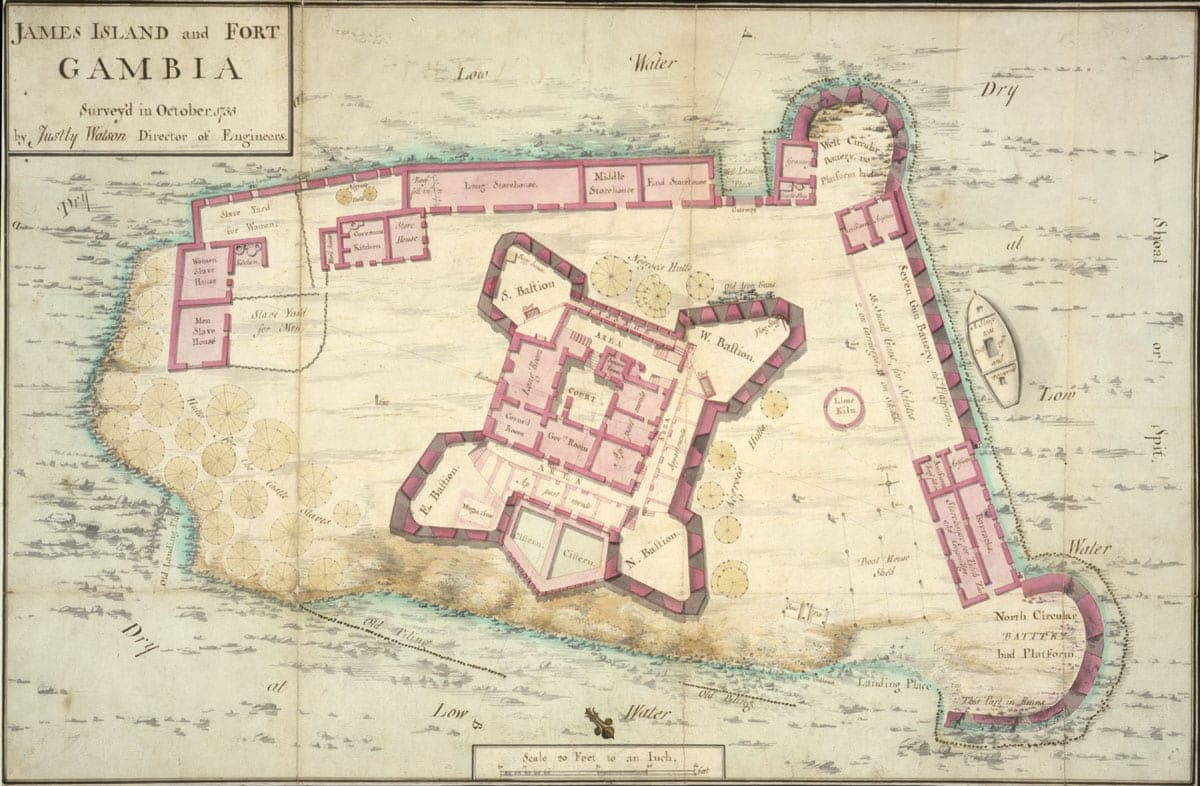
That older commerce was overtaken, and then deformed, by the Atlantic. Portuguese navigators entered the Gambia in the 1450s, the first Europeans to sail up an African river in search of trade with the interior, and English, French, Dutch and Baltic merchants followed. On a small island roughly thirty kilometres from the sea, settlers from the Duchy of Courland built a fort in 1651; the English seized it in 1661 and named the island and its fort for James, Duke of York, according to the record of Kunta Kinteh Island. For much of the next century and a half, James Island was a holding place in the transatlantic slave trade, one point in the machinery by which captured Africans were gathered, held and shipped across the ocean. It is remembered soberly, as it should be: a place of separation and loss for people whose names were mostly never written down, and whose descendants are scattered across the Americas.
Britain abolished the slave trade in 1807 and turned the same river to its suppression, establishing Bathurst in 1816 and settling freed people at MacCarthy Island upstream. Colonial rule followed in stages: Bathurst became a Crown Colony, and in 1894 the inland territory along the river was declared a protectorate, governed indirectly through appointed chiefs, as set out in the history of the Gambia Colony and Protectorate. Groundnuts became the single export on which the colonial economy turned. Independence came on 18 February 1965 under Prime Minister Dawda Jawara, the country became a republic in 1970, and for much of the 1980s it formed a loose confederation with Senegal.
The country takes its name from the river, and the river's name is old. It is generally traced to a Mandinka word for the water, rendered by early Portuguese sailors as Gambra or Cambra and settled over time into Gambia; the definite article in "the Gambia" preserves the sense of a place named for a single defining feature, according to Britannica. English is the language of government, courts and schooling, but a second language for almost everyone.
The living languages are African. Mandinka, a Manding tongue carried west from the Mali empire, is the most widely spoken and the classic language of the griot's art. Wolof, shared with Senegal, is the language of much of the coast and of commerce. Fula (Pulaar) is spoken by the cattle-keeping Fula across the region, and Jola and Serahule hold their own communities and territories. Most Gambians move easily between several of these, and the spread of Mandinka and Wolof across the Senegalese frontier is a reminder that nation and language map do not coincide.
The defining figure of Gambian and wider Manding culture is the griot, known in Mandinka as the jali: a hereditary keeper of memory who serves as historian, praise-singer, genealogist and diplomat in a society that long recorded its past in speech rather than writing. The signature instrument is the kora, a twenty-one-string harp-lute built over a large calabash, played alongside the balafon, a wooden xylophone with gourd resonators, and the ngoni lute. Female griots, the jelimuso, are celebrated singers whose praise at a wedding or naming can lift a family's standing, and Gambian kora dynasties such as the Suso and Jobarteh families have carried the tradition onto the world's concert stages.
Other traditions run just as deep. Traditional wrestling is a national sport and a village spectacle, its bouts opened by drumming and the wrestlers' own boasting songs. Dress carries meaning: men wear the flowing embroidered kaftan and women bright wrapper-and-blouse ensembles of West African tie-dye and strip-woven cloth. The national dish is domoda, a groundnut stew of meat or fish simmered with tomato and served over rice. Benachin, the Wolof "one pot" of rice cooked with fish and vegetables, is the dish of Friday lunches, and superkanja, a thick okra stew, rounds out a table where families eat together from a communal bowl.
The Gambia is overwhelmingly Muslim, with roughly ninety-five per cent of the population following Islam, most of it Sunni and much of it shaped by the Sufi brotherhoods, the Tijaniyya and the Qadiriyya, whose teachers knit the region together. Islam arrived along the trade routes that carried Mandinka settlement and has shaped Gambian life for centuries. A Christian minority, mostly Roman Catholic and Anglican and concentrated among the Aku and some Jola communities, makes up most of the remainder, and the two faiths share public holidays and, often, extended families.
Beneath the scriptural religions runs an older layer of belief in ancestors, spirits and the powers of place, expressed through masquerade, divination and the amulets, the jujus, that many Gambians of all faiths still carry. Islam here has long accommodated these customs rather than erased them, and the naming ceremony, funeral and harvest blend Quranic recitation with older practice.
Gambian mourning follows two braided threads, the Islamic and the customary, rarely separated in practice. When a death occurs, word travels fast and neighbours gather at once to help. Following Islamic rite, the body is washed, wrapped in a plain white shroud and buried quickly, usually within a day, after prayers at the mosque, as local custom records. The formal mourning period is commonly three days, during which the household receives a steady stream of visitors who bring food, sit in shared silence and offer prayer; a widow observes the longer Islamic mourning of four months and ten days. Loud lamentation, especially by women, is an accepted and public expression of grief.
 The island was renamed for the character in Alex Haley's Roots, and it is eroding: it is a fraction of the size it was when the fort on it was holding people for shipment. Photograph by Leonora Enking, CC BY-SA 2.0, via Wikimedia Commons.
Alongside the mosque stand the older obligations of kinship, and here the griot's role turns from celebration to memory. At funerals the jali recites the genealogy of the dead, naming the ancestors in order and setting the life within the long line of a family, so that to be remembered is to be spoken back into the chain. The same voice that praises a child at the naming ceremony, the ngente held seven days after birth, is the voice that closes the account at the end. For families of standing, the rites can run for days.
Over all this lies a national grief that belongs to the diaspora as much as to the Gambia: the memory of the slave trade, held at Kunta Kinteh Island and the villages of Albreda and Juffureh, is a mourning that reaches across the Atlantic. For the descendants of the enslaved, a visit to the island is an act of remembrance for forebears whose names were taken with their freedom.
More people have thought about Gambian genealogy than about that of most countries its size, and the reason is one book.
Alex Haley traced his American family back to a man he identified as Kunta Kinte of Juffure, and published Roots in 1976. The scholarship has since been hard on the specifics of that identification, but the effect was not undone by the criticism: Roots made African American genealogy a mass pursuit, brought hundreds of thousands of people to the Gambia, and put a village on the map. Kunta Kinteh Island and the related sites were inscribed by UNESCO in 2003.
The deeper Gambian record is the griot's. Jali families are professional keepers of genealogy and history, and their knowledge is transmitted within the family across generations and performed rather than filed. In Mandinka, Wolof and Fula society the griot can place a family within lineages going back centuries, and the Kouyaté and Diabaté lineages carry the epic of Sunjata, which is the founding record of the whole region.
The written archive is thinner. British colonial administration produced files divided between Banjul and Kew, and mission and Islamic school records carry some vital events. Civil registration is a modern development.
For African American and Afro-Caribbean families the practical route is the reverse of the usual one: identify a port of embarkation from an American record, then work with the Gambian and Senegalese oral traditions and the slave-voyage databases rather than expecting a register.
The Gambia holds two UNESCO World Heritage Sites, both of them concerned with memory. Kunta Kinteh Island and Related Sites, inscribed in 2003, gathers seven locations along the river, the island and its fort, the ruins of a Portuguese chapel and the settlement of San Domingo, the trading houses of Albreda and Juffureh, and the abolition-era Fort Bullen and Six-Gun Battery, into a single record of the slave trade's beginning and end on the river. The island itself is disappearing: erosion has reduced it to a fraction of its former size, and conservation is a race against the water.
The second site, the Stone Circles of Senegambia, was inscribed in 2006 and is shared with Senegal. It comprises four large groups, Wassu and Kerbatch in the Gambia and Sine Ngayène and Wanar in Senegal, drawn from a far larger field of more than a thousand circles and burial mounds spread across the country between the Gambia and Saloum rivers. The circles are built of laterite pillars, quarried with iron tools and dressed into cylinders or polygons that stand about two metres high and can weigh several tonnes each, raised over burials between roughly the third century BCE and the sixteenth century CE. Kerbatch holds a rare bifid, or V-shaped, stone, the only one of its kind in the region, and the concentration of the monuments makes the zone one of the largest such groupings anywhere.
Institutional stewardship rests with the National Centre for Arts and Culture (NCAC), which runs the National Museum of the Gambia in Banjul, opened in 1985, along with the museum at Juffureh and the stone circle sites, and curates the country's ethnographic and oral-history collections.
The Gambia's oldest archive is not written but spoken, kept by the griot families whose recitations preserve genealogies stretching back centuries. Efforts to record jali performances and oral histories join the wider work of documenting Manding culture before its master practitioners pass, while Gambian and diaspora musicians have carried the kora onto streaming platforms and given an ancient instrument a durable digital life.
For the harder history, the records that matter most sit in the archives of the nations that ran the trade, and their gradual digitisation, of shipping ledgers and the databases of transatlantic voyages, lets descendants trace connections back to the Gambia River that were once unrecoverable.
The single event that changed the Gambia's place in the world's imagination was Alex Haley's 1976 novel and the television series that followed. Haley traced his American family to an ancestor he named Kunta Kinte, said to have been seized near the village of Juffureh, and his search turned a small stretch of the Gambia River into a place of pilgrimage for the African diaspora. Whatever the debates over the book's precise history, its effect on remembrance was real and lasting.
The Gambia built on it. Since 1996 the government, through the NCAC, has staged the International Roots Festival, a homecoming that brings people of African descent from the Americas and Europe to trace heritage, visit Kunta Kinteh Island and Juffureh, and join in music, ceremony and reflection. For many who come, it is the closest they will get to a homeland taken from their ancestors, and it has made the Gambia a fixed point in the geography of diaspora memory. Its kora masters carry that culture outward in the other direction, on the world's stages and to a new generation abroad.
Two World Heritage inscriptions. In three years the Gambia won UNESCO recognition for both the memory of the slave trade at Kunta Kinteh Island in 2003 and the ancient monumental landscape it shares with Senegal, the Stone Circles of Senegambia in 2006.
The Roots homecoming. From one family's search for its name grew a national festival that has, since 1996, welcomed the diaspora back and given the memory of the enslaved a living place of return at Juffureh and on the island itself.
The jali tradition on the world stage. Gambian griot families have carried the kora from village ceremonies to international concert halls, keeping a hereditary art of memory alive while making it new.
The island was renamed for the character in Alex Haley's Roots, and it is eroding: it is a fraction of the size it was when the fort on it was holding people for shipment. Photograph by Leonora Enking, CC BY-SA 2.0, via Wikimedia Commons.
Alongside the mosque stand the older obligations of kinship, and here the griot's role turns from celebration to memory. At funerals the jali recites the genealogy of the dead, naming the ancestors in order and setting the life within the long line of a family, so that to be remembered is to be spoken back into the chain. The same voice that praises a child at the naming ceremony, the ngente held seven days after birth, is the voice that closes the account at the end. For families of standing, the rites can run for days.
Over all this lies a national grief that belongs to the diaspora as much as to the Gambia: the memory of the slave trade, held at Kunta Kinteh Island and the villages of Albreda and Juffureh, is a mourning that reaches across the Atlantic. For the descendants of the enslaved, a visit to the island is an act of remembrance for forebears whose names were taken with their freedom.
More people have thought about Gambian genealogy than about that of most countries its size, and the reason is one book.
Alex Haley traced his American family back to a man he identified as Kunta Kinte of Juffure, and published Roots in 1976. The scholarship has since been hard on the specifics of that identification, but the effect was not undone by the criticism: Roots made African American genealogy a mass pursuit, brought hundreds of thousands of people to the Gambia, and put a village on the map. Kunta Kinteh Island and the related sites were inscribed by UNESCO in 2003.
The deeper Gambian record is the griot's. Jali families are professional keepers of genealogy and history, and their knowledge is transmitted within the family across generations and performed rather than filed. In Mandinka, Wolof and Fula society the griot can place a family within lineages going back centuries, and the Kouyaté and Diabaté lineages carry the epic of Sunjata, which is the founding record of the whole region.
The written archive is thinner. British colonial administration produced files divided between Banjul and Kew, and mission and Islamic school records carry some vital events. Civil registration is a modern development.
For African American and Afro-Caribbean families the practical route is the reverse of the usual one: identify a port of embarkation from an American record, then work with the Gambian and Senegalese oral traditions and the slave-voyage databases rather than expecting a register.
The Gambia holds two UNESCO World Heritage Sites, both of them concerned with memory. Kunta Kinteh Island and Related Sites, inscribed in 2003, gathers seven locations along the river, the island and its fort, the ruins of a Portuguese chapel and the settlement of San Domingo, the trading houses of Albreda and Juffureh, and the abolition-era Fort Bullen and Six-Gun Battery, into a single record of the slave trade's beginning and end on the river. The island itself is disappearing: erosion has reduced it to a fraction of its former size, and conservation is a race against the water.
The second site, the Stone Circles of Senegambia, was inscribed in 2006 and is shared with Senegal. It comprises four large groups, Wassu and Kerbatch in the Gambia and Sine Ngayène and Wanar in Senegal, drawn from a far larger field of more than a thousand circles and burial mounds spread across the country between the Gambia and Saloum rivers. The circles are built of laterite pillars, quarried with iron tools and dressed into cylinders or polygons that stand about two metres high and can weigh several tonnes each, raised over burials between roughly the third century BCE and the sixteenth century CE. Kerbatch holds a rare bifid, or V-shaped, stone, the only one of its kind in the region, and the concentration of the monuments makes the zone one of the largest such groupings anywhere.
Institutional stewardship rests with the National Centre for Arts and Culture (NCAC), which runs the National Museum of the Gambia in Banjul, opened in 1985, along with the museum at Juffureh and the stone circle sites, and curates the country's ethnographic and oral-history collections.
The Gambia's oldest archive is not written but spoken, kept by the griot families whose recitations preserve genealogies stretching back centuries. Efforts to record jali performances and oral histories join the wider work of documenting Manding culture before its master practitioners pass, while Gambian and diaspora musicians have carried the kora onto streaming platforms and given an ancient instrument a durable digital life.
For the harder history, the records that matter most sit in the archives of the nations that ran the trade, and their gradual digitisation, of shipping ledgers and the databases of transatlantic voyages, lets descendants trace connections back to the Gambia River that were once unrecoverable.
The single event that changed the Gambia's place in the world's imagination was Alex Haley's 1976 novel and the television series that followed. Haley traced his American family to an ancestor he named Kunta Kinte, said to have been seized near the village of Juffureh, and his search turned a small stretch of the Gambia River into a place of pilgrimage for the African diaspora. Whatever the debates over the book's precise history, its effect on remembrance was real and lasting.
The Gambia built on it. Since 1996 the government, through the NCAC, has staged the International Roots Festival, a homecoming that brings people of African descent from the Americas and Europe to trace heritage, visit Kunta Kinteh Island and Juffureh, and join in music, ceremony and reflection. For many who come, it is the closest they will get to a homeland taken from their ancestors, and it has made the Gambia a fixed point in the geography of diaspora memory. Its kora masters carry that culture outward in the other direction, on the world's stages and to a new generation abroad.
Two World Heritage inscriptions. In three years the Gambia won UNESCO recognition for both the memory of the slave trade at Kunta Kinteh Island in 2003 and the ancient monumental landscape it shares with Senegal, the Stone Circles of Senegambia in 2006.
The Roots homecoming. From one family's search for its name grew a national festival that has, since 1996, welcomed the diaspora back and given the memory of the enslaved a living place of return at Juffureh and on the island itself.
The jali tradition on the world stage. Gambian griot families have carried the kora from village ceremonies to international concert halls, keeping a hereditary art of memory alive while making it new.
National Overview
Notable Cities
Historical Foundations
Linguistic and Etymological Roots
Cultural Identity
Religion and Spirituality
Remembrance and Mourning Traditions
Tracing a Family in The Gambia
Heritage Preservation Efforts
Digital Heritage
Contemporary Cultural Influences
Success Stories
References and resources
- UNESCO World Heritage Centre: Kunta Kinteh Island and Related Sites. The 2003 inscription and its seven component sites.
- UNESCO World Heritage Centre: Stone Circles of Senegambia. The 2006 transnational inscription shared with Senegal.
- Wikipedia: Kunta Kinteh Island. The island's names, colonial history and erosion.
- Wikipedia: Stone Circles of Senegambia. The megalithic field, pillar construction and dating.
- Encyclopaedia Britannica: The Gambia. Geography, peoples, the river and the country's name.
- Wikipedia: Kaabu. The Mandinka kingdom and its Mali origins.
- Wikipedia: Gambia Colony and Protectorate. British colony, protectorate and the road to 1965.
- Wikipedia: Janjanbureh (Georgetown). The upriver town, MacCarthy Island and the freed-slave settlement.
- My Gambia: The role of the griot and the origins of the kora. The jali tradition and its instruments.
- AccessGambia: Islamic burials and funerals. Funerary and mourning customs.
- AccessGambia: International Roots Festival. The diaspora homecoming since 1996.
- Wikipedia: Gambian cuisine. Domoda, benachin and the communal table.