Heritage · Landmark
The Nazca Lines: drawings on the desert floor
On a high desert plateau in southern Peru, the Nazca people scored a hummingbird, a monkey, a spider, and hundreds of ruler-straight lines into the ground, and the driest air on Earth has kept them legible for two thousand years. They were mapped as a star calendar, reinterpreted as ritual paths to water, and guarded for half a century by one woman with a broom.Written to last.
By Confinity Heritage Editorial · 2026-08-23 · 7-minute readQuiet tools, kept out of the way.
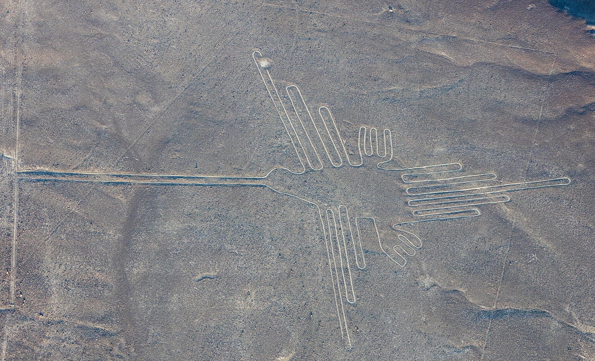
In the desert of southern Peru, between the towns of Nazca and Palpa and about 400 kilometres down the coast from Lima, a high arid plateau carries the largest drawings on Earth. Across roughly 450 square kilometres of reddish pampa, ancient hands traced a hummingbird, a monkey with a spiralled tail, a spider, a condor, a whale, flowering plants, and dozens of other figures, about seventy in all, together with hundreds of arrow-straight lines and broad cleared trapezoids, some of the lines running unbroken for kilometres. From the ground the marks read as faint pale paths. From the air they resolve into confident single-stroke images, drawn as though the desert were a page. Since 1994 they have been inscribed on the UNESCO World Heritage List as the Lines and Geoglyphs of Nasca and Palpa.
The lines were never entirely forgotten. Local people knew the pale traces, and Spanish chroniclers noted strange marks on the pampa as early as the sixteenth century. But it took the twentieth century to see them whole. When aircraft began crossing the region in the 1920s and 1930s, pilots and passengers looked down and realised that the faint paths were pictures. What followed is one of the most devoted chapters in the history of archaeology, involving a June sunset, a German mathematician who gave the desert her whole life, and, in our own decade, drones and a machine-learning model that keep finding figures no one had noticed for two thousand years.
The pampa is paved with small stones darkened by long ages of oxidation, a coating geologists call desert varnish. Beneath that dark skin lies pale, yellowish ground. To draw, the Nazca removed rather than added: they lifted away the oxidised stones to a depth of ten or fifteen centimetres and often stacked them along the edges, so that every line is a shallow trench of light bordered by ridges of dark. No pigment, no carving, no construction. A figure the size of a city block could be made with baskets, cords, and patience.
Work that shallow should not have survived, and almost anywhere else on Earth it would not have. The Nazca plateau is one of the driest places on the planet, with rainfall so scarce that annual totals are measured in millimetres. It is also strangely still. The dark stones soak up the sun and warm the air just above the surface, and that cushion of heated air, together with the sheltering hills, keeps the wind from scouring the ground. With almost no rain to wash the lines away and almost no wind to bury them, the desert has simply held the page open.
The drawings belong mostly to the Nazca culture, which flourished in the narrow river valleys along this coast from roughly 100 BC to AD 800. The Nazca are also remembered for vivid polychrome pottery, for fine textiles, and for the puquios, spiral-entered underground aqueducts that still carry water beneath the desert today. Their great ceremonial centre, Cahuachi, a complex of adobe mounds overlooking the pampa, seems to have been a place of pilgrimage rather than a city. Some figures are older still: the Paracas culture that preceded the Nazca set human-like figures on hillsides, where they can be seen from the valley floor without any aircraft at all.
The lines predate the Inca by many centuries; by the time Machu Picchu rose in the high Andes in the fifteenth century, the hummingbird had already lain in the desert for well over a thousand years.
The modern study of the lines begins with an American historian of irrigation. Paul Kosok came to the valley in 1941 to study ancient canals, and one June evening, near the southern winter solstice, he stood at the end of a long cleared line and watched the sun set almost directly over it. Struck by the coincidence, he called the pampa "the largest astronomy book in the world" and proposed that the lines pointed to events in the sky.
The idea found its great worker in Maria Reiche, a German-born mathematician then earning her living in Lima as a translator and tutor. Kosok recruited her in the 1940s, and when he moved on she stayed. For five decades she measured, swept, and mapped the figures, often alone, publishing her theory in Mystery on the Desert in 1949: the lines, she argued, formed a vast calendar, marking solstices and the rising points of stars that told the valley farmers when water would come. Her surveys, made with tape, sextant, and borrowed Air Force flights, remain the foundation of every map of the pampa.
The astronomical reading did not fully survive testing. In 1968 the astronomer Gerald Hawkins ran the alignments through a computer and found that the lines pointed at sun, moon, and star positions no more often than chance would predict. Later researchers, among them Anthony Aveni, Johan Reinhard, and long-running Peruvian and German field projects around Palpa, shifted attention from the sky to the ground. The straight lines radiate from natural rises and often connect to watercourses. Smashed pottery clusters at the ends of lines, as offerings would. And every great figure is drawn in a single unbroken path that never crosses itself, wide enough to walk in file.
The view most scholars now hold is that the lines were ritual pathways, walked in ceremonies bound up with water and fertility in a land where a river's failure meant famine. The trapezoids may have served as gathering places, the animal figures as images offered to the mountains and gods who sent the water. Astronomy has not been dismissed entirely, and Reiche's solstice alignments may well be real for a handful of lines, but the pampa no longer reads as a star atlas. It reads as processional architecture, drawn for the feet as much as the eye.
Whatever the lines mean, their survival through the twentieth century is owed largely to one person. Maria Reiche moved out to the edge of the pampa and lived there for decades in a small house without comforts, rising before dawn to measure while the low sun raked the ridges into visibility. She swept the figures clean with an ordinary broom, chased vehicles off the desert, paid guards out of her own pocket, lobbied ministers in Lima, and spent her prize money on a metal viewing tower beside the highway so that visitors could see the figures without walking on them.
Peru noticed. The woman locals had once taken for an eccentric foreigner became the Lady of the Lines, decorated by the state and granted honorary citizenship. When she died in June 1998, at ninety five, she was given a funeral with full honours and buried near the desert she had kept. Her house is now a museum.
The pampa is still giving up drawings. Since the 2000s, teams from Yamagata University in Japan, led by the archaeologist Masato Sakai, have surveyed the desert with aerial photography, drones, and machine learning. In 2019 they announced 143 previously unknown geoglyphs, one of them located with the help of an AI model. In 2024 an AI-assisted survey published with IBM researchers added 303 more figurative geoglyphs in six months of fieldwork, roughly doubling the known total. Many of the new figures are small, only a few metres across, older in style, and placed beside trails, showing people, heads, and animals to travellers on foot. The tradition began earlier and served walkers long before it served the gods of the great pampa figures.
Everything that makes the lines legible makes them fragile. A surface that forgets nothing in two thousand years also remembers every footprint. The Pan-American Highway was driven across the pampa in the 1930s, cutting through the figure of a lizard. In December 2014, Greenpeace activists walked into the restricted zone beside the hummingbird to lay out a banner for a climate summit, leaving scars in the desert varnish and prompting a national outcry and a formal apology. In January 2018 a truck driver ignored the warnings and drove across the plain, gouging tire marks over parts of three geoglyphs. Each wound will outlive everyone now alive.
Light aircraft circle the figures from the Nazca airfield, the roadside towers show the tree and the hands, and several figures, along with the older Paracas hillside drawings, are visible from the surrounding foothills. Which answers the claim, still in circulation, that the lines were runways or signals for visitors from space. The evidence says otherwise: wooden survey stakes found at the line ends carbon-date to Nazca times, the method needs nothing but cords and baskets, and many figures were always visible from the hills above. The theory's real flaw is not its physics but its condescension. The Nazca needed no help from the sky. They needed dry air and straight cords, and they had both.
The Nazca Lines upend the usual idea of a monument. They were not built up but taken away, not meant to be seen whole but to be moved through, one person wide, in lines of walkers crossing a desert toward water that might or might not come. Their makers never saw the hummingbird as we see it, entire and weightless from a circling plane, and did not need to. The drawing was the walking.
That such things still exist is a kind of miracle of neglect and care in equal measure. Nothing protects them but the stillness of the air, the near absence of rain, and the vigilance that Maria Reiche began with a broom and a ladder and that Peru now continues with guards, towers, and drones. A page kept open for two thousand years can be closed by one storm or one careless driver. The lines endure as a reminder that some memory is not stored in vaults or carved in stone at all, but held in the thinnest possible layer of the world, and kept only because, generation after generation, someone chooses to keep sweeping.
Drawings made by taking away
The people of the river valleys
The largest astronomy book in the world
Paths meant for feet
The guardian with the broom
New figures from drones and algorithms
One rain shower, one tire track
Drawings meant to be walked
References and resources
- UNESCO World Heritage Centre. "Lines and Geoglyphs of Nasca and Palpa." World Heritage List, property no. 700, inscribed 1994. whc.unesco.org/en/list/700.
- Encyclopaedia Britannica. "Nazca Lines." britannica.com/place/Nazca-Lines.
- Wikipedia. "Nazca lines," "Maria Reiche," and "Paul Kosok." Retrieved 2026.
- Reiche, Maria. Mystery on the Desert. Lima, 1949.
- Sakai, Masato, and colleagues. "AI-accelerated survey of the Nazca geoglyphs." Proceedings of the National Academy of Sciences, 2024.
- The Guardian. "Hundreds of mysterious Nazca glyphs uncovered in Peru with help of AI." September 2024.
- Smithsonian Magazine. "Greenpeace Apologizes for Damaging Nazca Lines." December 2014.