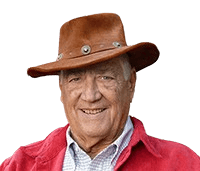
An elderly man wearing a brown leather cowboy hat and a red jacket smiles warmly at the camera. He stands in front of a wooden fence with greenery in the background, giving the image an outdoorsy, rustic feel. His friendly expression and casual attire convey a relaxed, approachable vibe.

Waldo Tobler

Historical

Historical

Nov 16, 1930

-

Feb 20, 2018

Biography

FAQ

Quotes

Biography

Waldo Tobler is one of the most prominent geographers and cartographers, and he is credited for his work in developing Geographic Information Science (GIS) and formulating Tobler's First Law of Geography. Tobler was born in 1930 in Portland, Oregon, and was raised in a multicultural context that he believes led to his interest in geography. Tobler was raised rovingly because his father worked for the Swiss consular service, which gave the young Tobler an experience in different areas.

He then enlisted in the U.S. Army and served as an intelligence analyst during the Korean War, which further helped him develop analytical skills. Following the war, Tobler continued his education in geography and received a Ph.D. from the University of Washington in 1961. Tobler participated in the quantitative revolution in geography, which focused on applying mathematical models and statistics to geographical problems.

Tobler worked for several decades, where he helped to lay the groundwork in cartography, spatial analysis, and GIS. He contributed to developing contemporary geographic information systems and supported using computers to improve cartographic techniques. In 1970, Tobler famously articulated the First Law of Geography: "Everything is connected to everything else, but neighbors are more connected than strangers." This law became a foundation for spatial analysis and is still relevant to geography and other related fields. He also made a considerable contribution to developing map projections, cartograms, and flow maps and analyzing how geographic data can be represented and interpreted.

Before joining the University of Michigan, Tobler taught at the University of California, Santa Barbara, where he retired as an emeritus professor. His impact was global, as he was honored with many awards and recognitions, such as the ESRI Lifetime Achievement Award and membership in the GIS Hall of Fame. Tobler's legacy in geography is long-standing, and his research continues to influence areas as varied as urban planning, demography, and transport.

Quotes

"Everything is related to everything else, but near things are more related than distant things."

"The usefulness of a GIS is constrained by its spatial resolution."

"A map is a powerful tool in the hands of the geographer, able to convey patterns that words cannot."

"Spatial analysis is at the heart of geography, enabling us to understand the world around us."

"Distance decay is not just a theory; it is a practical reality that shapes human behavior."

"Cartography is both an art and a science, requiring precision and creativity."

"To understand the complexity of cities, one must understand the flows of people and goods."

"The future of geography lies in the integration of data with advanced computational techniques."

"We must continue to develop new methods for visualizing geographic phenomena."

"In spatial analysis, proximity is the key to unlocking many of the mysteries of human behavior."

"Geography is not just the study of place; it is the study of how place influences everything else."

"Maps are more than representations; they are tools for inquiry."

"Geography, like all sciences, must evolve with technology to remain relevant."

"The intersection of geography and technology has the potential to solve many of today's problems."

"The power of GIS lies in its ability to reveal patterns invisible to the naked eye."

FAQ

What is Tobler's First Law of Geography?

Tobler's First Law holds that "everything is related to everything else but those things which are close together are more related than those which are far apart."

What makes Waldo Tobler a giant in GIS?

Tobler was the first to use computers in cartography and geographic analysis, contributing to the founding of GIS as a science.

Cartograms are maps that distort the size of areas to reflect a different attribute; what did Tobler do for them?

Cartograms are maps in which geographic areas are distorted to represent data. Though they had been in use earlier, Tobler was one of the early pioneers in the use of computer-generated cartograms.

What was Tobler's main contribution to spatial analysis?

His First Law of Geography has become the basis for the contemporary approach to spatial analysis. It underlines the role of contact in geographic interactions.

What are flow maps, and how did Tobler contribute to them?

Movement maps may depict the flow of people, commodities, or data. Tobler then programmed software to automatically generate flow maps and improve their quality and usefulness.

What impact did Tobler's hiking function have on geographic modeling?

He got his Ph.D. in geography from the University of Washington and was one of the quantitative revolution geographers who emphasized quantitative methods more than qualitative ones.

What did Tobler study in school?

He got his Ph.D. in geography from the University of Washington and was one of the quantitative revolution geographers who emphasized quantitative methods more than qualitative ones.

What is Tobler's Second Law of Geography?

According to Tobler's Second Law, external events determine what happens in a particular area of interest.

What accolades did Tobler gain during his working years?

He received many awards, including the ESRI Lifetime Achievement Award and the Waldo Tobler GIScience Prize of the Austrian Academy of Sciences.

What did Tobler do for the modern cartography?

He developed new techniques in analytical cartography and computations in which maps depict spatial relations more accurately.

Biography

FAQ

Quotes

Biography

Waldo Tobler is one of the most prominent geographers and cartographers, and he is credited for his work in developing Geographic Information Science (GIS) and formulating Tobler's First Law of Geography. Tobler was born in 1930 in Portland, Oregon, and was raised in a multicultural context that he believes led to his interest in geography. Tobler was raised rovingly because his father worked for the Swiss consular service, which gave the young Tobler an experience in different areas.

He then enlisted in the U.S. Army and served as an intelligence analyst during the Korean War, which further helped him develop analytical skills. Following the war, Tobler continued his education in geography and received a Ph.D. from the University of Washington in 1961. Tobler participated in the quantitative revolution in geography, which focused on applying mathematical models and statistics to geographical problems.

Tobler worked for several decades, where he helped to lay the groundwork in cartography, spatial analysis, and GIS. He contributed to developing contemporary geographic information systems and supported using computers to improve cartographic techniques. In 1970, Tobler famously articulated the First Law of Geography: "Everything is connected to everything else, but neighbors are more connected than strangers." This law became a foundation for spatial analysis and is still relevant to geography and other related fields. He also made a considerable contribution to developing map projections, cartograms, and flow maps and analyzing how geographic data can be represented and interpreted.

Before joining the University of Michigan, Tobler taught at the University of California, Santa Barbara, where he retired as an emeritus professor. His impact was global, as he was honored with many awards and recognitions, such as the ESRI Lifetime Achievement Award and membership in the GIS Hall of Fame. Tobler's legacy in geography is long-standing, and his research continues to influence areas as varied as urban planning, demography, and transport.

Quotes

"Everything is related to everything else, but near things are more related than distant things."

"The usefulness of a GIS is constrained by its spatial resolution."

"A map is a powerful tool in the hands of the geographer, able to convey patterns that words cannot."

"Spatial analysis is at the heart of geography, enabling us to understand the world around us."

"Distance decay is not just a theory; it is a practical reality that shapes human behavior."

"Cartography is both an art and a science, requiring precision and creativity."

"To understand the complexity of cities, one must understand the flows of people and goods."

"The future of geography lies in the integration of data with advanced computational techniques."

"We must continue to develop new methods for visualizing geographic phenomena."

"In spatial analysis, proximity is the key to unlocking many of the mysteries of human behavior."

"Geography is not just the study of place; it is the study of how place influences everything else."

"Maps are more than representations; they are tools for inquiry."

"Geography, like all sciences, must evolve with technology to remain relevant."

"The intersection of geography and technology has the potential to solve many of today's problems."

"The power of GIS lies in its ability to reveal patterns invisible to the naked eye."

FAQ

What is Tobler's First Law of Geography?

Tobler's First Law holds that "everything is related to everything else but those things which are close together are more related than those which are far apart."

What makes Waldo Tobler a giant in GIS?

Tobler was the first to use computers in cartography and geographic analysis, contributing to the founding of GIS as a science.

Cartograms are maps that distort the size of areas to reflect a different attribute; what did Tobler do for them?

Cartograms are maps in which geographic areas are distorted to represent data. Though they had been in use earlier, Tobler was one of the early pioneers in the use of computer-generated cartograms.

What was Tobler's main contribution to spatial analysis?

His First Law of Geography has become the basis for the contemporary approach to spatial analysis. It underlines the role of contact in geographic interactions.

What are flow maps, and how did Tobler contribute to them?

Movement maps may depict the flow of people, commodities, or data. Tobler then programmed software to automatically generate flow maps and improve their quality and usefulness.

What impact did Tobler's hiking function have on geographic modeling?

He got his Ph.D. in geography from the University of Washington and was one of the quantitative revolution geographers who emphasized quantitative methods more than qualitative ones.

What did Tobler study in school?

He got his Ph.D. in geography from the University of Washington and was one of the quantitative revolution geographers who emphasized quantitative methods more than qualitative ones.

What is Tobler's Second Law of Geography?

According to Tobler's Second Law, external events determine what happens in a particular area of interest.

What accolades did Tobler gain during his working years?

He received many awards, including the ESRI Lifetime Achievement Award and the Waldo Tobler GIScience Prize of the Austrian Academy of Sciences.

What did Tobler do for the modern cartography?

He developed new techniques in analytical cartography and computations in which maps depict spatial relations more accurately.

Life and achievements

Early life

Waldo Rudolph Tobler was born on November 16, 1930, in Portland, Oregon, to parents of Swiss origin. He was brought up in a traveling fashion due to his father's job in the Swiss consular service. He probably developed this interest in geography when he was young due to his exposure to different cultures and terrains.

The family traveled often, lived in Seattle, Washington, for a while, and then lived in Washington, D.C., where Tobler attended junior high school during World War II. In 1945, after the war, his family moved back to Switzerland, and Tobler went to high school in Zurich. During these years, he became fascinated with maps, spatial configuration, and geographic dynamics that would later define his academic pursuit.

Tobler enlisted in the U.S. Army at 18 to escape the compulsory enlistment in the Swiss military. In the Korean War, he worked as an intelligence analyst and interpreter, fluent in English, French, and German. This strengthened his analytical skills, which he used later in geography. Tobler left the military in 1952 and, utilizing the G.I. Bill, joined the University of British Columbia before transferring to the University of Washington, where he received his B.A., M.A., and Ph.D. in geography. His academic path unfolded when the quantitative revolution in geography occurred, and mathematical models and statistical methods were applied to analyze geographical processes.

Legacy

Waldo Tobler's contribution to geography and GIS has dramatically impacted theoretical and applied geography. He pioneered analytical cartography – a branch that applies mathematical methods to produce better maps with more excellent value. His spatial interpolation, flow mapping, and cartogram work revolutionized how geographic data is depicted with enhanced accuracy and understanding.

Tobler's First Law of Geography—asserting that "everything is related to everything else, but things closer together are more related than things further apart" —remains one of the essential principles in spatial analysis and is relevant in numerous fields ranging from economics to urban planning and environmental science.

Tobler's work was also instrumental in creating GIS, a tool now central to contemporary geography. His initial research on computer cartography paved the way for modern-day digital mapping systems. Tobler completed his Ph.D. in geography at the University of Michigan in 1962. He was a professor there and later at the University of California, Santa Barbara, until his retirement in 2000, where he inspired generations of students and researchers to use GIS as a fundamental approach to geographical research. He has touched more than just academia; the Waldo Tobler GIScience Prize, the Austrian Academy of Sciences gives to those who contribute to geographic information science, and his impact will continue to be felt for many years.

Tobler also contributed to geography through his developments in data display, especially cartograms and flow maps. His work influenced how data is visualized to represent several geographic phenomena still used in demography, transportation, and other fields. One example of his practical work on geographic issues is his hiking function, which simulated walking speeds depending on the surface type. Tobler was honored with many awards, such as the ESRI Lifetime Achievement Award, and his work is still referenced in current geographic research.

Come build your legacy!

Your donation today shapes the future of how families and friends connect.
You will become a featured Ambassador.
Learn more ->

Powered by

Come build your legacy!

Your donation today shapes the future of how families and friends connect.
You will become a featured Ambassador.
Learn more ->

Powered by

Come build your legacy!

Your donation today shapes the future of how families and friends connect.
You will become a featured Ambassador.
Learn more ->

Powered by

Milestone moments

Nov 16, 1930

Birth of a Geographic Pioneer
Waldo Tobler was born to Swiss-American parents in Portland, Oregon, USA.
His father's diplomatic job introduced Tobler to different geographical areas and zones, and he traveled from childhood.

This international upbringing helped Tobler develop a passion for geography, which he would later study and work in.
His early education in Switzerland, after the family moved back to Europe after the war, seemed to have influenced his intellectual development.

Tobler preferred maps, spatial distributions, and geographical changes by the time he joined the university.
These early influences laid the foundation for his later work in geography, which was innovative.

Apr 17, 1961

Doctorate in Geography
Tobler received his Ph.D. in geography from the University of Washington in 1961.
His dissertation, "Map Transformations of Geographic Space," was the basis for his future cartography and spatial analysis research.

While studying at the University of Washington, Tobler participated in the quantitative revolution in geography, which aimed to use mathematical and statistical tools for analyzing geographic data.
This movement would shape his career in the years to come.

His doctoral work laid the foundation for his subsequent developments in GIS and computer cartography by offering new approaches to analyzing geographic information.

Mar 12, 1970

Tobler's First Law of Geography
In 1970, Tobler summarized his findings in what became known as the First Law of Geography: "Everything is related to everything else, but near things are more related than distant things."
This concept was established as the basis for spatial analysis.

The law was introduced in a paper that focused on the growth of cities in Detroit, although its relevance was broader than just urbanism.
It was adopted as a fundamental concept within geographical studies that shaped how spatial relations are defined and dissected.

Tobler's First Law remains applicable and influential today.
It is still quoted in GIS, economics, and regional science.

Aug 14, 1977

Transfer to the University of California, Santa Barbara
The following year, Tobler was appointed to the faculty at the University of California at Santa Barbara, where he remained until his retirement.
At UCSB, he further developed his interest in cartography and spatial analysis, advising many students.

His work at UCSB contributed to the university's growth of geographic information science.
Tobler worked with other famous geographers to turn GIS into an effective tool for spatial analysis.

Tobler's impact at UCSB was not only in the classroom but also in the field of GIS and cartography worldwide.
His contributions are credited with developing contemporary geographic information systems.
Join the waitlist

Follow our journey as we build Confinity and be first to get early access to our platform.

Join the waitlist

Follow our journey as we build Confinity and be first to get early access to our platform.

Join the waitlist

Follow our journey as we build Confinity and be first to get early access to our platform.